IMAGES TAKEN NEAR TO
Owlthorpe Rise, SHEFFIELD, S20 5PA
Introduction
This page details the photographs taken nearby to Owlthorpe Rise, S20 5PA by members of the Geograph project.
The Geograph project started in 2005 with the aim of publishing, organising and preserving representative images for every square kilometre of Great Britain, Ireland and the Isle of Man.

There are currently over 7.5m images from over14,400 individuals and you can help contribute to the project by visiting https://www.geograph.org.uk
Image Map
Images are licensed for reuse under creativecommons.org/licenses/by-sa/2.0
Notes
- Clicking on the map will re-center to the selected point.
- The higher the marker number, the further away the image location is from the centre of the postcode.
Image Listing (13 Images Found)
Images are licensed for reuse under creativecommons.org/licenses/by-sa/2.0
Image
Details
Distance

2

Bus shelter on Mosborough Moor (A6135)
Heading north west.
Image: © JThomas
Taken: 7 Mar 2015
0.06 miles
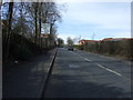
5

Mosborough Moor
View down Mosborough Moor towards Mosborough. Showing junction with Owlthorpe Drive.
Image: © Geoffrey Lumb
Taken: 1 Dec 2007
0.13 miles
7
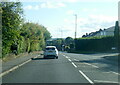
Mosborough Moor (A6135)
Heading north west towards Sheffield City Centre.
Image: © JThomas
Taken: 7 Mar 2015
0.18 miles