IMAGES TAKEN NEAR TO
New School Road, SHEFFIELD, S20 5ES
Introduction
This page details the photographs taken nearby to New School Road, S20 5ES by members of the Geograph project.
The Geograph project started in 2005 with the aim of publishing, organising and preserving representative images for every square kilometre of Great Britain, Ireland and the Isle of Man.

There are currently over 7.5m images from over14,400 individuals and you can help contribute to the project by visiting https://www.geograph.org.uk
Image Map (Loading...)


Getting Data...Please wait
Leaflet Map data © OpenStreetMap
Images are licensed for reuse under creativecommons.org/licenses/by-sa/2.0
Notes
- Clicking on the map will re-center to the selected point.
- The higher the marker number, the further away the image location is from the centre of the postcode.
Image Listing (36 Images Found)
Images are licensed for reuse under creativecommons.org/licenses/by-sa/2.0
Image
Details
Distance
1
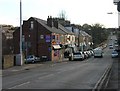
High Street, Mosborough, Nr Sheffield.
Image: © Andrew Loughran
Taken: 8 Feb 2006
0.04 miles
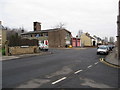
2
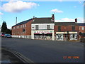
Mosborough High Street and junction with Station Road.
Image: © Andrew Loughran
Taken: 8 Feb 2006
0.04 miles
4
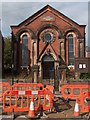
The Salvation Army Church, Queen Street, Mosborough
Image: © Neil Theasby
Taken: 21 Sep 2011
0.05 miles
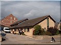
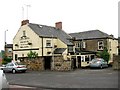
6
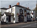
"The Queen" pub restaurant at Mosborough
Image: © Neil Theasby
Taken: 21 Sep 2011
0.09 miles

9
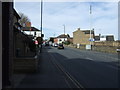
High Street, Mosborough
Approaching the Queen public house (on the left).
Image: © JThomas
Taken: 7 Mar 2015
0.10 miles
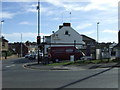
10
Queens Hotel Mosborough - view from Queen Street.
Image: © Andrew Loughran
Taken: 20 Jun 2006
0.10 miles