IMAGES TAKEN NEAR TO
Bramley Close, SHEFFIELD, S20 5BH
Introduction
This page details the photographs taken nearby to Bramley Close, S20 5BH by members of the Geograph project.
The Geograph project started in 2005 with the aim of publishing, organising and preserving representative images for every square kilometre of Great Britain, Ireland and the Isle of Man.

There are currently over 7.5m images from over14,400 individuals and you can help contribute to the project by visiting https://www.geograph.org.uk
Image Map
Images are licensed for reuse under creativecommons.org/licenses/by-sa/2.0
Notes
- Clicking on the map will re-center to the selected point.
- The higher the marker number, the further away the image location is from the centre of the postcode.
Image Listing (16 Images Found)
Images are licensed for reuse under creativecommons.org/licenses/by-sa/2.0
Image
Details
Distance
1
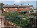
Vegetable gardens and backs of houses from Plumbley Lane
Image: © Neil Theasby
Taken: 21 Sep 2011
0.08 miles
2
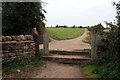
Bridle Stile Bridleway
Believed to originally be a packhorse route dating from 13th century
Image: © Graham Hogg
Taken: 23 Aug 2013
0.11 miles
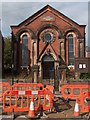
5
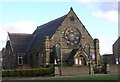
Mosborough Methodist Church near Sheffield.
Image: © Andrew Loughran
Taken: 8 Feb 2006
0.17 miles
6
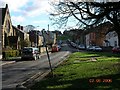
Chapel Street, Mosborough, Nr Sheffield
Image: © Andrew Loughran
Taken: 8 Feb 2006
0.17 miles
7
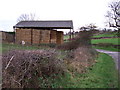
Barn at Plumbley.
Hay barn at the back of Plumbley lane Farm.
Image: © John Poyser
Taken: 3 Jan 2007
0.20 miles
9
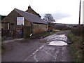
Plumbley Lane Farm.
Old farm now being renovated.
Image: © John Poyser
Taken: 3 Jan 2007
0.21 miles
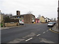
10
The Salvation Army Church, Queen Street, Mosborough
Image: © Neil Theasby
Taken: 21 Sep 2011
0.22 miles