IMAGES TAKEN NEAR TO
Norgreave Way, SHEFFIELD, S20 4TN
Introduction
This page details the photographs taken nearby to Norgreave Way, S20 4TN by members of the Geograph project.
The Geograph project started in 2005 with the aim of publishing, organising and preserving representative images for every square kilometre of Great Britain, Ireland and the Isle of Man.

There are currently over 7.5m images from over14,400 individuals and you can help contribute to the project by visiting https://www.geograph.org.uk
Image Map (Loading...)


Getting Data...Please wait
Leaflet Map data © OpenStreetMap
Images are licensed for reuse under creativecommons.org/licenses/by-sa/2.0
Notes
- Clicking on the map will re-center to the selected point.
- The higher the marker number, the further away the image location is from the centre of the postcode.
Image Listing (13 Images Found)
Images are licensed for reuse under creativecommons.org/licenses/by-sa/2.0
Image
Details
Distance
3
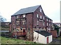
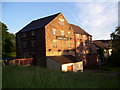
Joseph Glover Public House at Westfield
Former grain mill situated on Station Road. This pub used to serve customers across three floors but was closed for business as of the date of posting (February 2012)
Image: © Jonathan Clitheroe
Taken: 29 Feb 2012
0.14 miles
4
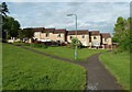
Houses set back from Station Road
A strip of parkland with trees runs between the road and the modern housing estate to the north. These houses are on Garland Croft.
Image: © Andrew Hill
Taken: 30 May 2011
0.15 miles
5
School Avenue
Tween-war development off Rotherham Road
Image: © Alan Murray-Rust
Taken: 19 Sep 2008
0.18 miles
6

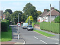
Rotherham Road, Halfway
In the distance, the old alignment of the road can be seen, still in use as a service road for some houses.
Image: © Richard Vince
Taken: 31 Aug 2013
0.20 miles
7
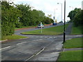
Side road by Eckington Way
Looking across the end of School Avenue to the main B6053 Eckington Way beyond.
Image: © Andrew Hill
Taken: 30 May 2011
0.20 miles
8
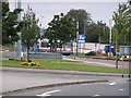
Tram terminus, Halfway
The end of the line as far as the Sheffield tram system is concerned. From here, it's about 35 minutes to the City Centre. From this view looking North, down to the right is the road into Killamarsh.
Image: © David Morris
Taken: 18 Sep 2005
0.22 miles
9
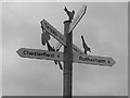
Signpost, Halfway
Yes, it's Halfway, but if it's only half way I don't fancy the rest of the walk to Timbuktu. This sign is lurking behind a new housing development just off the main road between Halfway and Killamarsh and points the way to Arnold Lavers and Morrisons.
Image: © David Morris
Taken: 18 Sep 2005
0.22 miles