IMAGES TAKEN NEAR TO
Gartrice Gardens, SHEFFIELD, S20 4SU
Introduction
This page details the photographs taken nearby to Gartrice Gardens, S20 4SU by members of the Geograph project.
The Geograph project started in 2005 with the aim of publishing, organising and preserving representative images for every square kilometre of Great Britain, Ireland and the Isle of Man.

There are currently over 7.5m images from over14,400 individuals and you can help contribute to the project by visiting https://www.geograph.org.uk
Image Map
Images are licensed for reuse under creativecommons.org/licenses/by-sa/2.0
Notes
- Clicking on the map will re-center to the selected point.
- The higher the marker number, the further away the image location is from the centre of the postcode.
Image Listing (5 Images Found)
Images are licensed for reuse under creativecommons.org/licenses/by-sa/2.0
Image
Details
Distance
1

County Boundary
The footpath from Windmill Hill towards Killamarsh marks the county boundary between Derbyshire and South Yorkshire.
Image: © John Poyser
Taken: 3 Jan 2007
0.20 miles
3
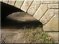
Benchmark on the bridge east of Windmill Hill
Image: © John Slater
Taken: 10 Apr 2013
0.24 miles
4

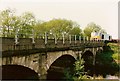
Railway bridge over River Rother
Between Killamarsh and Halfway. The line runs north from here to Sheffield.
Image: © Peter Barr
Taken: 11 Jul 2012
0.24 miles
5
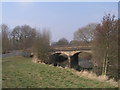
Railway bridge over the River Rother east of Windmill Hill
Image: © John Slater
Taken: 10 Apr 2013
0.24 miles