IMAGES TAKEN NEAR TO
Long Acre View, SHEFFIELD, S20 3FU
Introduction
This page details the photographs taken nearby to Long Acre View, S20 3FU by members of the Geograph project.
The Geograph project started in 2005 with the aim of publishing, organising and preserving representative images for every square kilometre of Great Britain, Ireland and the Isle of Man.

There are currently over 7.5m images from over14,400 individuals and you can help contribute to the project by visiting https://www.geograph.org.uk
Image Map
Images are licensed for reuse under creativecommons.org/licenses/by-sa/2.0
Notes
- Clicking on the map will re-center to the selected point.
- The higher the marker number, the further away the image location is from the centre of the postcode.
Image Listing (8 Images Found)
Images are licensed for reuse under creativecommons.org/licenses/by-sa/2.0
Image
Details
Distance
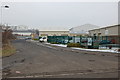
4
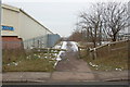
Factory entrance
On Station Road, Halfway.
Image: © Alan Murray-Rust
Taken: 19 Sep 2008
0.20 miles
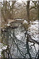
5
Cow Lane
The remains of Cow Lane a bridle path that linked Holbrook to School Road Beighton
Image: © John Jennings
Taken: 9 Feb 2012
0.20 miles
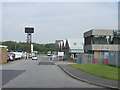
6
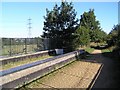
Transpennine trail near Killamarsh
This bridge - formerly railway between Bedgreave Mill (Rother Valley Park) and Renishaw is now part of the TPT that passes close to Rother Valley Park. The view is from the bridge over the road between Halfway and Killamarsh looking WNW towards the Holbrook industrial estate. The River Rother runs nearby.
Image: © David Morris
Taken: 17 Sep 2005
0.22 miles
7
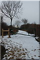
Path Rother Valley Way to Beighton & Mosborough
Image: © John Jennings
Taken: 9 Feb 2012
0.24 miles
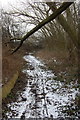
8
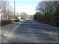
Station Road (B6058)
Heading south east towards Kilamarsh.
Image: © JThomas
Taken: 7 Mar 2015
0.25 miles