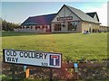
IMAGES TAKEN NEAR TO
Old Colliery Way, SHEFFIELD, S20 1DJ
Introduction
This page details the photographs taken nearby to Old Colliery Way, S20 1DJ by members of the Geograph project.
The Geograph project started in 2005 with the aim of publishing, organising and preserving representative images for every square kilometre of Great Britain, Ireland and the Isle of Man.

There are currently over 7.5m images from over14,400 individuals and you can help contribute to the project by visiting https://www.geograph.org.uk
Image Map
Images are licensed for reuse under creativecommons.org/licenses/by-sa/2.0
Notes
- Clicking on the map will re-center to the selected point.
- The higher the marker number, the further away the image location is from the centre of the postcode.
Image Listing (35 Images Found)
Images are licensed for reuse under creativecommons.org/licenses/by-sa/2.0
Image
Details
Distance
1
CADAC warehouse/factory, Swallownest
LIVE THE BRAAI LIFE is the slogan highlighted on the building and there's a windsock on the corner.
We were mystified by this. Apart from the fact that very few people would be able to read the slogan as the building faces nothing much, what was it all about? Ah, it's Afrikaans for the outdoor life, camping gas bbqs and all that sort of gear, see; http://www.cadac.uk.com/index.php
We wondered if the hierarchy of the company often fly in by helicopter.
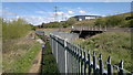
It's beside the old Great Central railway that used to be the mainline into Sheffield from Chesterfield and the south, before heading on towards Manchester through the Woodhead tunnels. The electrified line across the Pennines that was closed about 30 years ago!
Image: © Chris Morgan
Taken: 30 Apr 2012
0.05 miles
2
Railway viaduct, Woodhouse Mill
Under the Beighton railway viaduct on a crisp November morning. I just liked the setting! There's another picture for this square that's a better geograph!
Image: © David Morris
Taken: 19 Nov 2005
0.05 miles
3
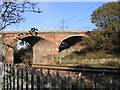
Railway crossing, Woodhouse Mill
Despite the ubiquitous 'orrible British Railway galvanised fence, this is a nice spot as the GC atop Beighton Viaduct crosses the MR. The GC (top) heads west-east towards Sheffield (left) and Kiveton (right). The MR comes down from Rotherham and heads down towards Chesterfield (behind me). The GC is interesting here because it's still controlled by semaphore signals.
Image: © David Morris
Taken: 19 Nov 2005
0.05 miles
5
Elmwood Farm near Swallownest
http://www.geograph.org.uk/photo/4908171
Image: © Ian S
Taken: 13 Apr 2016
0.12 miles
6
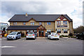
Elmwood Farm near Swallownest
http://www.geograph.org.uk/photo/4908171
Image: © Ian S
Taken: 13 Apr 2016
0.12 miles
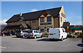
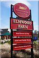
7
Elmwood Farm Carvery Restaurant
A new Restaurant which opened for business on 19 August 2013
Image: © Derek Henry
Taken: 26 Aug 2013
0.12 miles
8
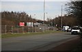
The sign says Rotherham
A view of the busy A57, nr the Beighton turn off.
Image: © roger geach
Taken: 24 Feb 2011
0.13 miles
9
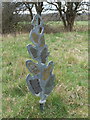
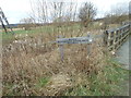
Marker Post
One of five markers showing former line of River Rother
Image: © John Jennings
Taken: 19 Mar 2012
0.13 miles
10
Elmwood Farm near Swallownest
http://www.geograph.org.uk/photo/4908167
Image: © Ian S
Taken: 13 Apr 2016
0.13 miles