IMAGES TAKEN NEAR TO
The Common, DRONFIELD, S18 7WP
Introduction
This page details the photographs taken nearby to The Common, S18 7WP by members of the Geograph project.
The Geograph project started in 2005 with the aim of publishing, organising and preserving representative images for every square kilometre of Great Britain, Ireland and the Isle of Man.

There are currently over 7.5m images from over14,400 individuals and you can help contribute to the project by visiting https://www.geograph.org.uk
Image Map
Images are licensed for reuse under creativecommons.org/licenses/by-sa/2.0
Notes
- Clicking on the map will re-center to the selected point.
- The higher the marker number, the further away the image location is from the centre of the postcode.
Image Listing (52 Images Found)
Images are licensed for reuse under creativecommons.org/licenses/by-sa/2.0
Image
Details
Distance
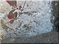
1
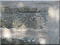
Ordnance Survey Cut Mark
This mark can be found on the wall of 3 Main Road
Image: © Peter Wood
Taken: 16 May 2012
0.05 miles
2
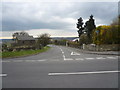
Horsleygate Lane - Junction with the B6054
Image: © Alan Heardman
Taken: 31 Mar 2009
0.05 miles
3
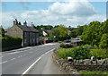
Main Road, Holmesfield Common
Looking west along the B6054. The houses on the left are just beyond the Horsleygate Lane turn.
Image: © Andrew Hill
Taken: 31 May 2011
0.06 miles
4
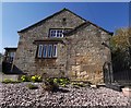
The Old Church Hall, St Swithin's, Holmesfield
Ebenezer Hall of Totley Grange laid the foundation stone. The old hall was replaced about 10 years ago and has been renovated for private use.
Image: © Chris Morgan
Taken: 21 Apr 2020
0.06 miles
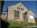
5
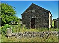
Disused chapel at Holmesfield Common
This Wesleyan Reform Chapel was erected in 1848. It could accommodate a hundred people.
Image: © Neil Theasby
Taken: 11 Aug 2022
0.06 miles
6
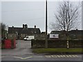
Penny Acres Primary School, Holmesfield
Half-term, getting repairs done
Image: © Peter Barr
Taken: 15 Feb 2010
0.07 miles
7
The Old Church Hall, St Swithin's, Holmesfield
Ebenezer Hall of Totley Grange laid the foundation stone. Sadly, the old hall was replaced a couple of years ago and is now lying empty. Hopefully a new use can be found for it.
Image: © Chris Morgan
Taken: 26 Mar 2012
0.08 miles
8
Ordnance Survey Cut Mark
This mark can be found on the gatepost of a house called Waitangi.
For more detail see : http://www.bench-marks.org.uk/bm43100
Image: © Peter Wood
Taken: 16 May 2012
0.09 miles