IMAGES TAKEN NEAR TO
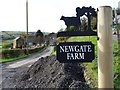
Newgate, DRONFIELD, S18 7TF
Introduction
This page details the photographs taken nearby to Newgate, S18 7TF by members of the Geograph project.
The Geograph project started in 2005 with the aim of publishing, organising and preserving representative images for every square kilometre of Great Britain, Ireland and the Isle of Man.

There are currently over 7.5m images from over14,400 individuals and you can help contribute to the project by visiting https://www.geograph.org.uk
Image Map
Images are licensed for reuse under creativecommons.org/licenses/by-sa/2.0
Notes
- Clicking on the map will re-center to the selected point.
- The higher the marker number, the further away the image location is from the centre of the postcode.
Image Listing (8 Images Found)
Images are licensed for reuse under creativecommons.org/licenses/by-sa/2.0
Image
Details
Distance
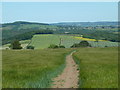
3
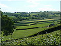
Valley view from Newgate
The quiet farming valley of Sud Brook from the hamlet of Newgate, set just below the brow of the hill.
Image: © Andrew Hill
Taken: 3 Jun 2011
0.08 miles
4
Footpath Junction near Bole Hill
Looking east towards Barlow on a very warm Saturday in late May.
Image: © Jonathan Clitheroe
Taken: 22 May 2010
0.10 miles
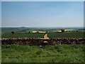
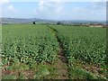
5
Footpath between Bole Hill and Barlow
The clear path descends gently eastward with fine views beyond the barley field in the foreground.
Image: © Andrew Hill
Taken: 3 Jun 2011
0.11 miles
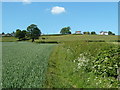
6
Barlow FP 39
Heading towards Barlow village from Bole Hill.
Image: © Dave Dunford
Taken: 23 Mar 2017
0.11 miles
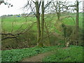
7
Path up to Newgate
Footpath up the valley side from Sud Brook.
Image: © Andrew Hill
Taken: 3 Jun 2011
0.15 miles
8
Footbridge over Sud Brook, south of Newgate
Image: © John Slater
Taken: 4 Apr 2017
0.23 miles