IMAGES TAKEN NEAR TO
Wilkin Hill, DRONFIELD, S18 7TE
Introduction
This page details the photographs taken nearby to Wilkin Hill, S18 7TE by members of the Geograph project.
The Geograph project started in 2005 with the aim of publishing, organising and preserving representative images for every square kilometre of Great Britain, Ireland and the Isle of Man.

There are currently over 7.5m images from over14,400 individuals and you can help contribute to the project by visiting https://www.geograph.org.uk
Image Map (Loading...)


Getting Data...Please wait
Leaflet Map data © OpenStreetMap
Images are licensed for reuse under creativecommons.org/licenses/by-sa/2.0
Notes
- Clicking on the map will re-center to the selected point.
- The higher the marker number, the further away the image location is from the centre of the postcode.
Image Listing (53 Images Found)
Images are licensed for reuse under creativecommons.org/licenses/by-sa/2.0
Image
Details
Distance
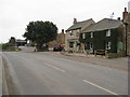
1
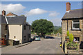
Barlow
Showing the bottom of Wilkin Hill where it joins the B6051.
Image: © Stephen McKay
Taken: 25 Aug 2007
0.03 miles
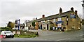
2
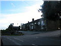
The Old Pump public house
This pub has recently changed its name to The Old Pump and is very near to the site of the old village pump.
Image: © Roger Temple
Taken: 1 Oct 2006
0.04 miles
5
The Peacock at Barlow
One of several pubs in the area. Website at http://www.thepeacockatbarlow.co.uk/
Image: © Dave Dunford
Taken: 23 Mar 2017
0.05 miles
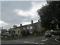
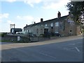
6
The Old Pump
It didn't need all hands to the pumps on this day, thanks to the road from Chesterfield being closed!
Image: © Chris Morgan
Taken: 18 Nov 2013
0.05 miles
7
Hackney House Caf?, Barlow
At the junction of Wilkin Hill with the B6051.
Image: © Dave Dunford
Taken: 23 Mar 2017
0.05 miles
8
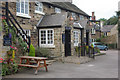
The Old Pump, Barlow
Until 2002 this stone-built village pub was called The Peacock - a common name for pubs in these parts, deriving from the family badge of the Manners family. The new name is derived from the pump for the well that at one time supplied the village with water on this site.
Image: © Stephen McKay
Taken: 25 Aug 2007
0.05 miles
9
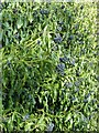
Ivy, Barlow
Ivy in fruit west of Barlow church.
Image: © Dave Dunford
Taken: 23 Mar 2017
0.05 miles