IMAGES TAKEN NEAR TO
Keepers Lane, DRONFIELD, S18 7SX
Introduction
This page details the photographs taken nearby to Keepers Lane, S18 7SX by members of the Geograph project.
The Geograph project started in 2005 with the aim of publishing, organising and preserving representative images for every square kilometre of Great Britain, Ireland and the Isle of Man.

There are currently over 7.5m images from over14,400 individuals and you can help contribute to the project by visiting https://www.geograph.org.uk
Image Map
Images are licensed for reuse under creativecommons.org/licenses/by-sa/2.0
Notes
- Clicking on the map will re-center to the selected point.
- The higher the marker number, the further away the image location is from the centre of the postcode.
Image Listing (20 Images Found)
Images are licensed for reuse under creativecommons.org/licenses/by-sa/2.0
Image
Details
Distance
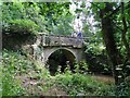
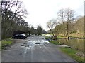
2
Lee Bridge near Commonside
Note the dog emerging from the brook with a stick while its owner looks on from the bank.
Image: © Jonathan Clitheroe
Taken: 27 Nov 2011
0.03 miles
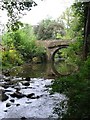
3
Entrance to Barlow Fishery
The Fishery is fed by the Barlow Brook (to the left, not visible in this picture) and is stocked with carp and trout. http://www.barlowlakes.co.uk/
Image: © Dave Dunford
Taken: 23 Mar 2017
0.04 miles
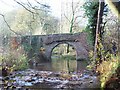
4
Barlow - Lee Bridge on Smelting House Lane
Image: © Dave Bevis
Taken: 9 Oct 2009
0.05 miles
5
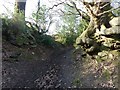
Gateland Lane
Before reaching open fields, Gateland Lane runs through a short hollow way where bedrock is visible to either side beneath tree roots.
Image: © Dave Dunford
Taken: 23 Mar 2017
0.06 miles
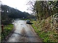
6
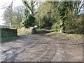
Start of Gateland Lane
Gateland Lane is the bridleway (Barlow BW 49) running up the hill; through the gateway on the left is the entrance to Barlow Fishery. http://www.barlowlakes.co.uk/
Image: © Dave Dunford
Taken: 23 Mar 2017
0.07 miles
7
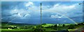
View of Barlow Brook valley from Rutland Terrace
Lots of grass and woodland
Image: © Toby Speight
Taken: 4 Jun 2005
0.08 miles
8
Building by footpath near Lea Bridge
A distinctive building by the path on the south side of Barlow Brook.
Image: © Andrew Hill
Taken: 24 May 2011
0.09 miles
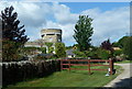
9
Caf? at Barlow Fishery
Sometimes billed as the "Fisherman's Friend" this small café and clubhouse is just upstream of Lee Bridge, Barlow Brook, which feeds the fishing lakes runs behind it.
Image: © Dave Dunford
Taken: 23 Mar 2017
0.09 miles
10
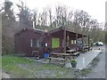
Caf? at Barlow Fishery
Sometimes billed as the "Fisherman's Friend" this small café and clubhouse is just upstream of Lee Bridge, Barlow Brook, which feeds the fishing lakes runs behind it.
Image: © Dave Dunford
Taken: 23 Mar 2017
0.09 miles