IMAGES TAKEN NEAR TO
Barlow, DRONFIELD, S18 7SE
Introduction
This page details the photographs taken nearby to S18 7SE by members of the Geograph project.
The Geograph project started in 2005 with the aim of publishing, organising and preserving representative images for every square kilometre of Great Britain, Ireland and the Isle of Man.

There are currently over 7.5m images from over14,400 individuals and you can help contribute to the project by visiting https://www.geograph.org.uk
Image Map
Images are licensed for reuse under creativecommons.org/licenses/by-sa/2.0
Notes
- Clicking on the map will re-center to the selected point.
- The higher the marker number, the further away the image location is from the centre of the postcode.
Image Listing (8 Images Found)
Images are licensed for reuse under creativecommons.org/licenses/by-sa/2.0
Image
Details
Distance
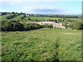
1
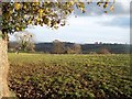
Pasture near Ridgeway House
Looking broadly towards Bolehill from the verge next to Far Lane.
Image: © Jonathan Clitheroe
Taken: 10 Nov 2012
0.04 miles
2
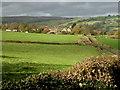
Barlow Woodseats
I am not sure where Woodseats comes from, its used in several place names in this area. This picture was taken from the west side of Allen Wood looking north north west
Image: © Roger Temple
Taken: 13 Nov 2006
0.14 miles
3
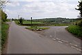
Junction of Far Lane and Wildaygreen Lane
Image: © Jerry Evans
Taken: 2 May 2009
0.16 miles
4
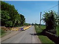
Roadworks on Far Lane
Severn and Trent Water roadworks near Rumbling Street. The area to the left of the road is Allen Wood.
Image: © Jonathan Clitheroe
Taken: 22 May 2010
0.18 miles
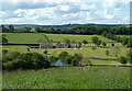
5

View of Crowhole Reservoir and Reservoir House
Image: © Neil Theasby
Taken: 12 May 2012
0.18 miles
6
Crowhole Reservoir View
The reservoir is currently empty, it would appear that some kind of mainenance work is taking place.
Image: © Alan Heardman
Taken: 16 Sep 2007
0.19 miles
7
Valley view overlooking Crowhole Reservoir
The setting of the reservoir now boasts a large new property nearby.
Image: © Andrew Hill
Taken: 31 May 2011
0.20 miles
