IMAGES TAKEN NEAR TO
Cowley Lane, DRONFIELD, S18 7SD
Introduction
This page details the photographs taken nearby to Cowley Lane, S18 7SD by members of the Geograph project.
The Geograph project started in 2005 with the aim of publishing, organising and preserving representative images for every square kilometre of Great Britain, Ireland and the Isle of Man.

There are currently over 7.5m images from over14,400 individuals and you can help contribute to the project by visiting https://www.geograph.org.uk
Image Map
Images are licensed for reuse under creativecommons.org/licenses/by-sa/2.0
Notes
- Clicking on the map will re-center to the selected point.
- The higher the marker number, the further away the image location is from the centre of the postcode.
Image Listing (17 Images Found)
Images are licensed for reuse under creativecommons.org/licenses/by-sa/2.0
Image
Details
Distance

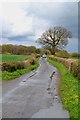
2
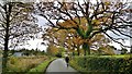
Approaching Greenfield Farm on Cowley Lane
Image: © Chris Morgan
Taken: 18 Nov 2013
0.07 miles
3
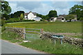
Cowley Lane, field and farm house
View by the junction with Dobbin Lane.
Image: © Andrew Hill
Taken: 24 May 2011
0.08 miles
4
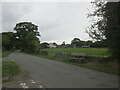
The Cowley Lane / Dobbin Lane junction
Image: © steven ruffles
Taken: 12 Sep 2021
0.14 miles
5
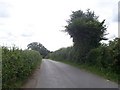
Cowley - Fields viewed from Cowley Lane
Image: © Alan Heardman
Taken: 18 Aug 2009
0.16 miles
6
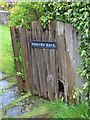
Garden gate, Cowley Hall near Holmesfield
Image: © Neil Theasby
Taken: 26 Apr 2012
0.17 miles
7
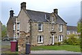
Cowley Hall, Cowley Lane near Holmesfield
Image: © Neil Theasby
Taken: 26 Apr 2012
0.17 miles
9
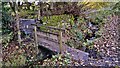
Footbridge across stream below Cowley Hall
Image: © Chris Morgan
Taken: 18 Nov 2013
0.23 miles
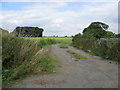
10
Dobbin Lane near Peakley Hill, Derbyshire
Image: © Neil Theasby
Taken: 26 Apr 2012
0.23 miles