IMAGES TAKEN NEAR TO
St. Johns Road, DRONFIELD, S18 4AH
Introduction
This page details the photographs taken nearby to St. Johns Road, S18 4AH by members of the Geograph project.
The Geograph project started in 2005 with the aim of publishing, organising and preserving representative images for every square kilometre of Great Britain, Ireland and the Isle of Man.

There are currently over 7.5m images from over14,400 individuals and you can help contribute to the project by visiting https://www.geograph.org.uk
Image Map
Images are licensed for reuse under creativecommons.org/licenses/by-sa/2.0
Notes
- Clicking on the map will re-center to the selected point.
- The higher the marker number, the further away the image location is from the centre of the postcode.
Image Listing (34 Images Found)
Images are licensed for reuse under creativecommons.org/licenses/by-sa/2.0
Image
Details
Distance
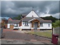
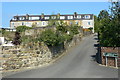
1
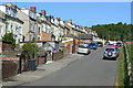
St John's Road, Unstone
Terraced houses built for colliery workers, riginally called New Row. This was originally the back of the houses but is now the main access for most people because of the advent of the motor car.
Image: © Alan Murray-Rust
Taken: 18 May 2010
0.01 miles
2
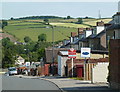
St John's Terrace, Unstone
Looking down a village street of terraced houses.
Image: © Andrew Hill
Taken: 14 Jun 2011
0.03 miles
3
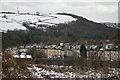
Unstone New Row
A long line of terraced cottages built, probably by the Unstone Coal and Coke Company, for workers in the local collieries. Named as New Row on the earliest OS 6" map, the 1900-ish edition calls it Long Row. The current road name is st John's Road.
Image: © Alan Murray-Rust
Taken: 23 Feb 2010
0.03 miles
4
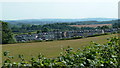
View towards terrace in Unstone
Looking across fields to the long line of St John's Road in Unstone.
Image: © Andrew Hill
Taken: 14 Jun 2011
0.03 miles
5
45-54 St John's Road, Unstone
This group of 10 houses is set at right angles to the main group, which is to the right of the picture. Note how every house has had a loft room added at some stage.
Image: © Alan Murray-Rust
Taken: 18 May 2010
0.05 miles