IMAGES TAKEN NEAR TO
Coalbrook Grove, SHEFFIELD, S13 9XS
Introduction
This page details the photographs taken nearby to Coalbrook Grove, S13 9XS by members of the Geograph project.
The Geograph project started in 2005 with the aim of publishing, organising and preserving representative images for every square kilometre of Great Britain, Ireland and the Isle of Man.

There are currently over 7.5m images from over14,400 individuals and you can help contribute to the project by visiting https://www.geograph.org.uk
Image Map
Images are licensed for reuse under creativecommons.org/licenses/by-sa/2.0
Notes
- Clicking on the map will re-center to the selected point.
- The higher the marker number, the further away the image location is from the centre of the postcode.
Image Listing (6 Images Found)
Images are licensed for reuse under creativecommons.org/licenses/by-sa/2.0
Image
Details
Distance
1
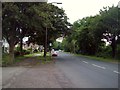
Railway bridge on Retford Road, Woodhouse Mill, Sheffield
Image: © Steve Fareham
Taken: 11 Jan 2009
0.07 miles
2
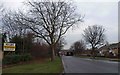
B6200 Retford Road at Woodhouse Hill
Looking towards the Handsworth area of Sheffield from the roadside beneath a Railway Bridge.
Image: © Jonathan Clitheroe
Taken: 1 Jul 2012
0.09 miles
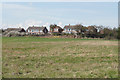
4
Vehicle Test Station on Orgreave Drive
Image: © Steve Fareham
Taken: 11 Jan 2009
0.21 miles
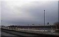
5
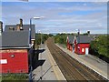
Woodhouse Station
When I 'were a lad' there were two passenger and two goods lines passing through here, and it wasn't bright red! One of the goods lines terminates behind the station building on the left. Just down the line in the distance (looking north-west) was the end of the Sheffield - Manchester - Wath 1500V DC electrified system that ran through the now disused Woodhead Tunnel.
Image: © David Morris
Taken: 17 Sep 2005
0.21 miles
6
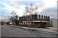
Disused industrial premises on Orgreave Drive
Image: © Neil Theasby
Taken: 7 Dec 2012
0.25 miles