IMAGES TAKEN NEAR TO
Ryan Drive, SHEFFIELD, S13 9UZ
Introduction
This page details the photographs taken nearby to Ryan Drive, S13 9UZ by members of the Geograph project.
The Geograph project started in 2005 with the aim of publishing, organising and preserving representative images for every square kilometre of Great Britain, Ireland and the Isle of Man.

There are currently over 7.5m images from over14,400 individuals and you can help contribute to the project by visiting https://www.geograph.org.uk
Image Map
Images are licensed for reuse under creativecommons.org/licenses/by-sa/2.0
Notes
- Clicking on the map will re-center to the selected point.
- The higher the marker number, the further away the image location is from the centre of the postcode.
Image Listing (4 Images Found)
Images are licensed for reuse under creativecommons.org/licenses/by-sa/2.0
Image
Details
Distance
1
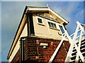
Woodhouse Junction signal box
Looking up at the recently refurbished Woodhouse Junction signalbox.
Image: © dave hudson
Taken: 4 Jan 2011
0.07 miles
3
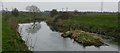
Woodhouse Washlands and River Rother
Woodhouse Washlands is a floodplain of the River Rother, Seen here at its normal level; in times of prolonged heavy rain the river can rise and burst its banks, flooding the whole site.
Image: © Mike Nield
Taken: 27 Mar 2017
0.16 miles
4
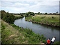
The River Rother, Woodhouse Mill
Looking North along the River Rother as it meanders along the Woodhouse Washlands towards Rotherrham.
Image: © Andy Davis
Taken: 11 Sep 2004
0.18 miles