IMAGES TAKEN NEAR TO
Beaver Avenue, SHEFFIELD, S13 9QH
Introduction
This page details the photographs taken nearby to Beaver Avenue, S13 9QH by members of the Geograph project.
The Geograph project started in 2005 with the aim of publishing, organising and preserving representative images for every square kilometre of Great Britain, Ireland and the Isle of Man.

There are currently over 7.5m images from over14,400 individuals and you can help contribute to the project by visiting https://www.geograph.org.uk
Image Map
Images are licensed for reuse under creativecommons.org/licenses/by-sa/2.0
Notes
- Clicking on the map will re-center to the selected point.
- The higher the marker number, the further away the image location is from the centre of the postcode.
Image Listing (5 Images Found)
Images are licensed for reuse under creativecommons.org/licenses/by-sa/2.0
Image
Details
Distance

2

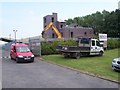
South Yorkshire Fire & Rescue Training Centre
Image: © Neil Theasby
Taken: 7 Dec 2012
0.19 miles
3

South Yorkshire Fire Training School
Formerly St John Fisher RC Secondary School back when I were a lad (1970's / 80s), this is now the training centre for South Yorkshire Fire and Rescue. The centre is on Beaver Hill Road between Handsworth and Woodhouse.
Image: © David Morris
Taken: 28 Jun 2006
0.21 miles
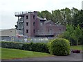
4
Fire service training site
Building the new extension to South Yorkshire Fire and Rescue Service Brigade Training Centre. This structure is more complex than the normal 'drill towers' seen at most local fire stations.
Image: © Martin Speck
Taken: 29 Jun 2009
0.21 miles
5
Fire & rescue training centre
South Yorkshire Fire & Rescue’s main training facilities are located here at the Training & Development Centre, Handsworth.
Image: © Graham Hogg
Taken: 31 May 2012
0.22 miles