IMAGES TAKEN NEAR TO
Orgreave Road, SHEFFIELD, S13 9LQ
Introduction
This page details the photographs taken nearby to Orgreave Road, S13 9LQ by members of the Geograph project.
The Geograph project started in 2005 with the aim of publishing, organising and preserving representative images for every square kilometre of Great Britain, Ireland and the Isle of Man.

There are currently over 7.5m images from over14,400 individuals and you can help contribute to the project by visiting https://www.geograph.org.uk
Image Map (Loading...)


Getting Data...Please wait
Leaflet Map data © OpenStreetMap
Images are licensed for reuse under creativecommons.org/licenses/by-sa/2.0
Notes
- Clicking on the map will re-center to the selected point.
- The higher the marker number, the further away the image location is from the centre of the postcode.
Image Listing (8 Images Found)
Images are licensed for reuse under creativecommons.org/licenses/by-sa/2.0
Image
Details
Distance
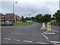
1
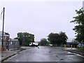
Industrial Area in Orgreave
Orgreave Drive pictured late on a Friday afternoon in early October.
Image: © Jonathan Clitheroe
Taken: 4 Oct 2013
0.06 miles
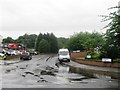
4
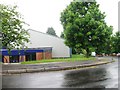
Orgreave Crescent
Orgreave Crescent is just a part of the large Dore House industrial estate.
Image: © Michael Patterson
Taken: 14 Jul 2006
0.18 miles