IMAGES TAKEN NEAR TO
Ballifield Place, SHEFFIELD, S13 9HT
Introduction
This page details the photographs taken nearby to Ballifield Place, S13 9HT by members of the Geograph project.
The Geograph project started in 2005 with the aim of publishing, organising and preserving representative images for every square kilometre of Great Britain, Ireland and the Isle of Man.

There are currently over 7.5m images from over14,400 individuals and you can help contribute to the project by visiting https://www.geograph.org.uk
Image Map (37 Images)


Getting Data...Please wait
Leaflet Map data © OpenStreetMap
Images are licensed for reuse under creativecommons.org/licenses/by-sa/2.0
Notes
- Clicking on the map will re-center to the selected point.
- The higher the marker number, the further away the image location is from the centre of the postcode.
Image Listing (37 Images Found)
Images are licensed for reuse under creativecommons.org/licenses/by-sa/2.0
Image
Details
Distance
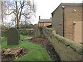
3
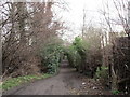
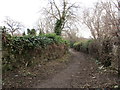
Footpath by the allotments
The tunnel like nature of this path is partly achieved by the presence of many holly bushes.
Image: © Jonathan Thacker
Taken: 30 Jan 2016
0.16 miles
5
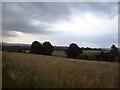
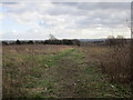
Looking Towards Woodhouse from Grange Lane
An open agricultural area sandwiched between Woodhouse, Handsworth and the Mosborough Parkway.
Image: © Jonathan Clitheroe
Taken: 10 Jun 2011
0.16 miles
10
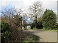
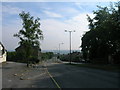
Grange Lane junction
Various paths and tracks come together at this point.
Image: © Jonathan Thacker
Taken: 30 Jan 2016
0.19 miles