IMAGES TAKEN NEAR TO
Stradbroke Road, SHEFFIELD, S13 8SN
Introduction
This page details the photographs taken nearby to Stradbroke Road, S13 8SN by members of the Geograph project.
The Geograph project started in 2005 with the aim of publishing, organising and preserving representative images for every square kilometre of Great Britain, Ireland and the Isle of Man.

There are currently over 7.5m images from over14,400 individuals and you can help contribute to the project by visiting https://www.geograph.org.uk
Image Map
Images are licensed for reuse under creativecommons.org/licenses/by-sa/2.0
Notes
- Clicking on the map will re-center to the selected point.
- The higher the marker number, the further away the image location is from the centre of the postcode.
Image Listing (15 Images Found)
Images are licensed for reuse under creativecommons.org/licenses/by-sa/2.0
Image
Details
Distance
2
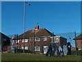
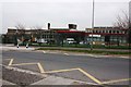
Strange metal sculptures near the perimeter fence of City School
Image: © Neil Theasby
Taken: 10 Nov 2010
0.04 miles
4
City School
This 1960s building is due for re-building in the next two years
Image: © Keith Pitchforth
Taken: 15 Apr 2010
0.08 miles
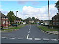
5
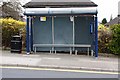
Bus Stop on Richmond
A standard bus stop
Image: © Keith Pitchforth
Taken: 15 Apr 2010
0.12 miles
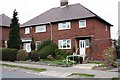
6
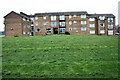
Blocks of Flats
One of many blocks on Stradbroke Road.
Image: © Keith Pitchforth
Taken: 15 Apr 2010
0.16 miles
7
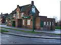
Richmond Estate Public House.
The Strad.at Richmond.
Image: © John Poyser
Taken: 5 Jan 2007
0.16 miles
8
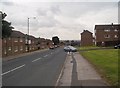
Stradbroke Road in Richmond
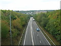
Looking in the direction of the Mosborough Parkway on an overcast Friday afternoon in late August.
Image: © Jonathan Clitheroe
Taken: 24 Aug 2012
0.17 miles
9
Ravencroft, Smelter Wood Drive, demolished
Image: © Alex McGregor
Taken: 6 Jul 2011
0.17 miles