IMAGES TAKEN NEAR TO
Car Vale View, SHEFFIELD, S13 8ES
Introduction
This page details the photographs taken nearby to Car Vale View, S13 8ES by members of the Geograph project.
The Geograph project started in 2005 with the aim of publishing, organising and preserving representative images for every square kilometre of Great Britain, Ireland and the Isle of Man.

There are currently over 7.5m images from over14,400 individuals and you can help contribute to the project by visiting https://www.geograph.org.uk
Image Map
Images are licensed for reuse under creativecommons.org/licenses/by-sa/2.0
Notes
- Clicking on the map will re-center to the selected point.
- The higher the marker number, the further away the image location is from the centre of the postcode.
Image Listing (8 Images Found)
Images are licensed for reuse under creativecommons.org/licenses/by-sa/2.0
Image
Details
Distance
1
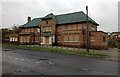
The Springwood is closed
A large estate pub, now boarded-up. When open it looked like this Image
Image: © David Lally
Taken: 28 Oct 2012
0.12 miles
2
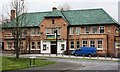
The Springwood Public House
Update: October 2012. Now closed Image
Image: © Keith Pitchforth
Taken: 15 Apr 2010
0.13 miles
3
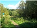
Path and Access Land near Car Brook
Car Brook itself is situated by the willow trees to the right of picture. I presume that this is the brook that gave the suburb near Attercliffe its name. It certainly appears to head in the direction of Carbrook before it disappears underground near Handsworth Avenue to the north.
Image: © Jonathan Clitheroe
Taken: 7 Sep 2012
0.15 miles
4
Danebrook Court, Sheffield
Submitted to the BBC Domesday Reloaded project. The main changes since 1986 is the growth of trees and the erection of a satellite dish. http://www.bbc.co.uk/history/domesday/dblock/GB-436000-384000/picture/2
Image: © Martin Speck
Taken: 2 Jul 2011
0.17 miles
5
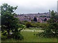
Looking over Gar Brook
Towards modern housing on the Manor housing estate.
Image: © Graham Hogg
Taken: 31 May 2012
0.19 miles
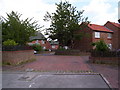
6
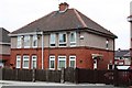
Social Housing from between the wars
The Manor area of Sheffield was a Council estate built in the 1930s
Image: © Keith Pitchforth
Taken: 15 Apr 2010
0.21 miles
7

Wooded Vista near Car Brook
A narrow but attractive tract of meadow nestled between Castlebeck Drive to the left and Woodthorpe Crescent. The view here marks out the course of Car Brook as it follows a north easterly route towards Bowden Howsteads Wood.
Image: © Jonathan Clitheroe
Taken: 7 Sep 2012
0.21 miles
8
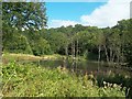
Fishing Lake at Car Brook
A 'hidden' lake in the sense that it isn't marked on the map! It's situated on Access Land just a stones throw from the busy Mosborough Parkway.
Image: © Jonathan Clitheroe
Taken: 7 Sep 2012
0.23 miles