IMAGES TAKEN NEAR TO
Lowburn Road, SHEFFIELD, S13 8DH
Introduction
This page details the photographs taken nearby to Lowburn Road, S13 8DH by members of the Geograph project.
The Geograph project started in 2005 with the aim of publishing, organising and preserving representative images for every square kilometre of Great Britain, Ireland and the Isle of Man.

There are currently over 7.5m images from over14,400 individuals and you can help contribute to the project by visiting https://www.geograph.org.uk
Image Map
Images are licensed for reuse under creativecommons.org/licenses/by-sa/2.0
Notes
- Clicking on the map will re-center to the selected point.
- The higher the marker number, the further away the image location is from the centre of the postcode.
Image Listing (30 Images Found)
Images are licensed for reuse under creativecommons.org/licenses/by-sa/2.0
Image
Details
Distance
4
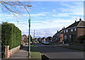
Cast Iron lamp post, Masefield Road
Still in operation.
This is the highest point of Richmond Hill, and where my lass comes from
Image: © David Lally
Taken: 8 Mar 2008
0.11 miles
5
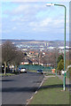
Woodrove Avenue
Looking straight down the hill.
Just right of centre are the cooling towers of the Blackburn Meadows power station next to the M1 at Tinsley Image The large white building to the right of that is the former British Steel Stainless plant - still producing, but currently owned by the Finnish company Outo Kumpu http://en.wikipedia.org/wiki/Outokumpu.
Also visible on the skyline to the left is Kepple's Column Image
Image: © David Lally
Taken: 8 Mar 2008
0.13 miles
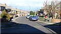
6
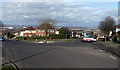
Top o 'ill
A No 25a reaches the highest point on its route at the junction of Woodrove Avenue and Chadwick Road.
Image: © David Lally
Taken: 8 Mar 2008
0.13 miles
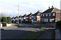
7
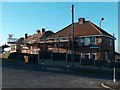
Houses at junction of Woodrove Avenue and Ulley Road, Sheffield 13
Image: © Neil Theasby
Taken: 10 Nov 2010
0.14 miles
8
Masefield Road
Atop the hill above the Woodthorpe council estate there is a few streets of non-council houses. Masefield Road runs for a few hundred yards along the very top of the hill, until, as seen in this shot, it turns towards the northwest and descends steeply.
Image: © David Lally
Taken: 8 Mar 2008
0.14 miles
9
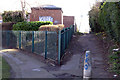
Strawberry Jennel
This path joins the top of Woodrove Avenue / end of Masefield Road to Richmond Road.
The graffitied building is an electrical substation.
Image: © David Lally
Taken: 8 Mar 2008
0.14 miles