IMAGES TAKEN NEAR TO
Bridby Street, SHEFFIELD, S13 7QE
Introduction
This page details the photographs taken nearby to Bridby Street, S13 7QE by members of the Geograph project.
The Geograph project started in 2005 with the aim of publishing, organising and preserving representative images for every square kilometre of Great Britain, Ireland and the Isle of Man.

There are currently over 7.5m images from over14,400 individuals and you can help contribute to the project by visiting https://www.geograph.org.uk
Image Map (Loading...)


Getting Data...Please wait
Leaflet Map data © OpenStreetMap
Images are licensed for reuse under creativecommons.org/licenses/by-sa/2.0
Notes
- Clicking on the map will re-center to the selected point.
- The higher the marker number, the further away the image location is from the centre of the postcode.
Image Listing (8 Images Found)
Images are licensed for reuse under creativecommons.org/licenses/by-sa/2.0
Image
Details
Distance
2
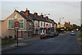
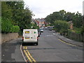
Shops, Beighton Road, Woodhouse
At the top of Beighton Road in Woodhouse stands a row of shops. The road down to the left goes past the railway station and on down to Woodhouse Mill.
Image: © David Morris
Taken: 28 Jun 2006
0.08 miles
3
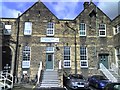
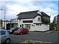
Brockwood Park Training Centre
The Brockwood Park Training Centre, part of Neighbourhoods and Community Care, Sheffield City Council. The building was originally Woodhouse County Junior School.
Image: © Dave Pickersgill
Taken: 2 Oct 2008
0.10 miles
8
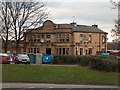
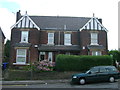
"The George" public house in Woodhouse
Image: © Neil Theasby
Taken: 24 Nov 2009
0.23 miles