IMAGES TAKEN NEAR TO
Oldale Close, SHEFFIELD, S13 7ND
Introduction
This page details the photographs taken nearby to Oldale Close, S13 7ND by members of the Geograph project.
The Geograph project started in 2005 with the aim of publishing, organising and preserving representative images for every square kilometre of Great Britain, Ireland and the Isle of Man.

There are currently over 7.5m images from over14,400 individuals and you can help contribute to the project by visiting https://www.geograph.org.uk
Image Map
Images are licensed for reuse under creativecommons.org/licenses/by-sa/2.0
Notes
- Clicking on the map will re-center to the selected point.
- The higher the marker number, the further away the image location is from the centre of the postcode.
Image Listing (5 Images Found)
Images are licensed for reuse under creativecommons.org/licenses/by-sa/2.0
Image
Details
Distance
1
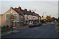
Shops, Beighton Road, Woodhouse
At the top of Beighton Road in Woodhouse stands a row of shops. The road down to the left goes past the railway station and on down to Woodhouse Mill.
Image: © David Morris
Taken: 28 Jun 2006
0.13 miles
2
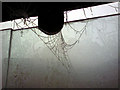
Standing in a Freezing Bus Stop
Bit of a chilly morning.
Image: © Darren Raynes
Taken: 19 Feb 2008
0.20 miles
3
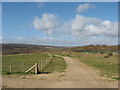
Linley Bank Meadow
View of Linley Bank Meadow, the restored Beighton tip, looking towards Intake.
Image: © Neill Schofield
Taken: 21 Mar 2014
0.21 miles
5
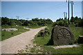
Site of Birley East Colliery
Though the last coal was drawn in 1943, Birley East Colliery served as a training facility for 'Bevin Boys' during World War II http://en.wikipedia.org/wiki/Birley_Collieries
The Trans-Pennine Trail now passes through the site
The commemorative stone records mining 1888-1943
Image: © Richard Croft
Taken: 17 Jun 2010
0.24 miles