IMAGES TAKEN NEAR TO
Wolverley Road, SHEFFIELD, S13 7EF
Introduction
This page details the photographs taken nearby to Wolverley Road, S13 7EF by members of the Geograph project.
The Geograph project started in 2005 with the aim of publishing, organising and preserving representative images for every square kilometre of Great Britain, Ireland and the Isle of Man.

There are currently over 7.5m images from over14,400 individuals and you can help contribute to the project by visiting https://www.geograph.org.uk
Image Map
Images are licensed for reuse under creativecommons.org/licenses/by-sa/2.0
Notes
- Clicking on the map will re-center to the selected point.
- The higher the marker number, the further away the image location is from the centre of the postcode.
Image Listing (11 Images Found)
Images are licensed for reuse under creativecommons.org/licenses/by-sa/2.0
Image
Details
Distance

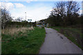
3
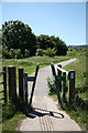
Trans-Pennine Trail
Ubiquitous anti-motorbike stile and TPT heading south from Stradbroke Road
Image: © Richard Croft
Taken: 17 Jun 2010
0.14 miles
5
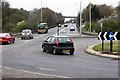
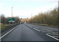
Handsworth Relief Road
Looking north towards the Sheffield Parkway
Image: © Keith Pitchforth
Taken: 15 Apr 2010
0.17 miles
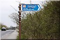
7
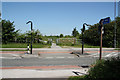
Trans-Pennine Trail
TPT crossing Stradbroke Road
Image: © Richard Croft
Taken: 17 Jun 2010
0.19 miles