IMAGES TAKEN NEAR TO
Ashwell Road, SHEFFIELD, S13 7EB
Introduction
This page details the photographs taken nearby to Ashwell Road, S13 7EB by members of the Geograph project.
The Geograph project started in 2005 with the aim of publishing, organising and preserving representative images for every square kilometre of Great Britain, Ireland and the Isle of Man.

There are currently over 7.5m images from over14,400 individuals and you can help contribute to the project by visiting https://www.geograph.org.uk
Image Map
Images are licensed for reuse under creativecommons.org/licenses/by-sa/2.0
Notes
- Clicking on the map will re-center to the selected point.
- The higher the marker number, the further away the image location is from the centre of the postcode.
Image Listing (13 Images Found)
Images are licensed for reuse under creativecommons.org/licenses/by-sa/2.0
Image
Details
Distance
3
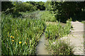
Shire Brook Valley Nature Reserve
Ponds and walkway at Shire Brook Valley Nature Reserve http://www.sheffield.gov.uk/out--about/parks-woodlands--countryside/trees--woodlands/south-east-sheffield-woodlands-project/shire-brook-local-nature
Image: © Richard Croft
Taken: 17 Jun 2010
0.17 miles
4
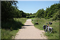
Shire Brook Valley Nature Reserve
Urban Nature Reserve http://www.sheffield.gov.uk/out--about/parks-woodlands--countryside/trees--woodlands/south-east-sheffield-woodlands-project/shire-brook-local-nature near Woodhouse
Image: © Richard Croft
Taken: 17 Jun 2010
0.18 miles
8
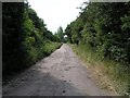
Stone Lane, Woodhouse
This road once served the sewage works and Badger Tools. Both have now gone, but the sewage works buildings have been converted into buildings for the Shirebrook Valley Nature Reserve. The end of the road (behind me) seems to be a place where old cars go to die, or be burned out by the local yoofs. The speed ramps are probably there to stop the yoofs damaging themselves too much when the cars are crashed into the gates at the end.
Image: © David Morris
Taken: 1 Jul 2006
0.22 miles
9
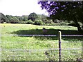
Highland Cattle in Sally Clarks Meadow
The Highland Cattle are in this Ancient Meadow every summer. At the time of taking this picture there were a couple of calves there too.
Image: © Darren Raynes
Taken: 9 Jun 2008
0.22 miles
10
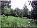
Green Meadow
It's hard to believe, looking at this picture, that the busy A57 is two minutes away from where I'm sat. Shire Brook Valley Nature Reserve is a real haven for both people and wildlife.
Image: © Darren Raynes
Taken: 5 Jun 2008
0.22 miles