IMAGES TAKEN NEAR TO
Water Slacks Way, SHEFFIELD, S13 7DQ
Introduction
This page details the photographs taken nearby to Water Slacks Way, S13 7DQ by members of the Geograph project.
The Geograph project started in 2005 with the aim of publishing, organising and preserving representative images for every square kilometre of Great Britain, Ireland and the Isle of Man.

There are currently over 7.5m images from over14,400 individuals and you can help contribute to the project by visiting https://www.geograph.org.uk
Image Map
Images are licensed for reuse under creativecommons.org/licenses/by-sa/2.0
Notes
- Clicking on the map will re-center to the selected point.
- The higher the marker number, the further away the image location is from the centre of the postcode.
Image Listing (10 Images Found)
Images are licensed for reuse under creativecommons.org/licenses/by-sa/2.0
Image
Details
Distance
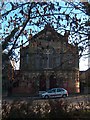
1
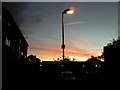
Red western sky
Took this image around a quarter to eight looking into Skelton Grove. I'm sure the local shepherds were delighted.
Image: © Darren Raynes
Taken: 14 Sep 2007
0.07 miles
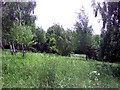
2
Highland Cattle in Sally Clarks Meadow
The Highland Cattle are in this Ancient Meadow every summer. At the time of taking this picture there were a couple of calves there too.
Image: © Darren Raynes
Taken: 9 Jun 2008
0.14 miles
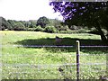
3
Green Meadow
It's hard to believe, looking at this picture, that the busy A57 is two minutes away from where I'm sat. Shire Brook Valley Nature Reserve is a real haven for both people and wildlife.
Image: © Darren Raynes
Taken: 5 Jun 2008
0.14 miles
4
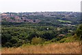
Looking over Shire Brook Valley
A nature reserve sandwiched between urban housing estates.
Image: © Graham Hogg
Taken: 23 Aug 2013
0.16 miles
5
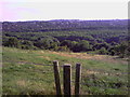
Overlooking Sally Clark's Field
Sally Clark lived in a cottage at the top of this field in the 1800's. Not much is known about her, but she was believed by many local people to be a witch. Beighton is in the background.
Image: © Darren Raynes
Taken: 8 Sep 2007
0.16 miles
6
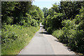
Stone Lane
Cycle route of the Trans-Pennine Trail by Shire Brook Valley Nature Reserve
Image: © Richard Croft
Taken: 17 Jun 2010
0.16 miles
8
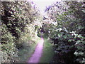
Trans Pennine Trail
This is the old Birley Collieries' branch railway line. The line served the Birley East and West collieries before being closed down in the 1950's. It also carried miners and their families on annual outings to the seaside. Today this trail can get you to Chesterfield, Leeds, York, Manchester, Southport on the west coast and Hornsea on the east coast.
Image: © Darren Raynes
Taken: 8 Sep 2007
0.19 miles
10
Standing in a Freezing Bus Stop
Bit of a chilly morning.
Image: © Darren Raynes
Taken: 19 Feb 2008
0.23 miles