IMAGES TAKEN NEAR TO
Hessey Street, SHEFFIELD, S13 7BL
Introduction
This page details the photographs taken nearby to Hessey Street, S13 7BL by members of the Geograph project.
The Geograph project started in 2005 with the aim of publishing, organising and preserving representative images for every square kilometre of Great Britain, Ireland and the Isle of Man.

There are currently over 7.5m images from over14,400 individuals and you can help contribute to the project by visiting https://www.geograph.org.uk
Image Map (Loading...)


Getting Data...Please wait
Leaflet Map data © OpenStreetMap
Images are licensed for reuse under creativecommons.org/licenses/by-sa/2.0
Notes
- Clicking on the map will re-center to the selected point.
- The higher the marker number, the further away the image location is from the centre of the postcode.
Image Listing (15 Images Found)
Images are licensed for reuse under creativecommons.org/licenses/by-sa/2.0
Image
Details
Distance
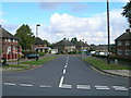
1
Former Council Housing on Normanton Grove
Image: © Keith Pitchforth
Taken: 15 Apr 2010
0.05 miles
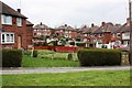
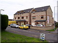
2
Netherwheel Cottages
Part of historic Normanton
Image: © Keith Pitchforth
Taken: 15 Apr 2010
0.09 miles
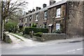
4
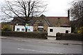
Converted School
A former primary school
Image: © Keith Pitchforth
Taken: 15 Apr 2010
0.10 miles
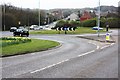
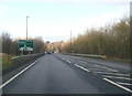
8
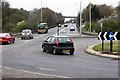
Handsworth Relief Road
Looking north towards the Sheffield Parkway
Image: © Keith Pitchforth
Taken: 15 Apr 2010
0.15 miles
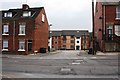
9
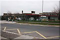
City School
This 1960s building is due for re-building in the next two years
Image: © Keith Pitchforth
Taken: 15 Apr 2010
0.16 miles