IMAGES TAKEN NEAR TO
Carr Forge Road, SHEFFIELD, S12 4FG
Introduction
This page details the photographs taken nearby to Carr Forge Road, S12 4FG by members of the Geograph project.
The Geograph project started in 2005 with the aim of publishing, organising and preserving representative images for every square kilometre of Great Britain, Ireland and the Isle of Man.

There are currently over 7.5m images from over14,400 individuals and you can help contribute to the project by visiting https://www.geograph.org.uk
Image Map (Loading...)


Getting Data...Please wait
Leaflet Map data © OpenStreetMap
Images are licensed for reuse under creativecommons.org/licenses/by-sa/2.0
Notes
- Clicking on the map will re-center to the selected point.
- The higher the marker number, the further away the image location is from the centre of the postcode.
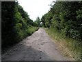
Image Listing (9 Images Found)
Images are licensed for reuse under creativecommons.org/licenses/by-sa/2.0
Image
Details
Distance
2
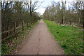
Centenary Ponds Shire Brook Nature Reserve
The ponds were dug in 1993 to celebrate the centenary of the City of Sheffield.
Image: © Darren Raynes
Taken: 8 Sep 2007
0.10 miles
3
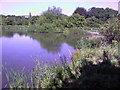
Carr Forge Dam
This picture was taken in August 2007 on a beautifully warm day. This is one of my favourite spots to have a bit of a sit and a think. Even though there's a busy road behind me it always seems peaceful here.
Image: © Darren Raynes
Taken: 24 Aug 2007
0.16 miles
4
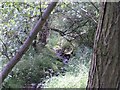
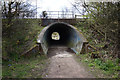
Shire Brook
In the Shirebrook Valley, the brook itself fed several waterwheels in times past including Image
Image: © David Morris
Taken: 1 Jul 2006
0.18 miles
5
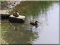
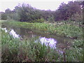
Ducks on Carr Forge Dam
Since a youngster nearly killed himself when his fishing pole touched overhead live wires a few years ago, fishing on the dam has been banned by order of Sheffield Council, so the ducks have free rein. Here, mummy-duck sits on the stone keeping an eye on youngster. As I cycled past, another five of this year's brood appeared out from under the shelter of the bank.
Image: © David Morris
Taken: 1 Jul 2006
0.18 miles
6
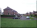
Dyke Vale Close
Local authority built housing at Hackenthorpe.
Image: © Martin Speck
Taken: 11 Aug 2009
0.22 miles
7
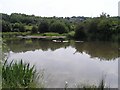
Carr Forge Dam
In the Shirebrook Valley below Woodhouse were several waterwheels, possibly dating back to Tudor times, and part of Sheffield's early industrial heritage. This shows Carr Forge Dam with the water levels lower than usual because of the prolonged dry spell. The Shire Brook was in times past the border between the ancient kingdoms of Mercia and Northumbria and more lately between Yorkshire and Derbyshire, hence the name Shire Brook.
Image: © David Morris
Taken: 1 Jul 2006
0.22 miles
8
Stone Lane, Woodhouse
This road once served the sewage works and Badger Tools. Both have now gone, but the sewage works buildings have been converted into buildings for the Shirebrook Valley Nature Reserve. The end of the road (behind me) seems to be a place where old cars go to die, or be burned out by the local yoofs. The speed ramps are probably there to stop the yoofs damaging themselves too much when the cars are crashed into the gates at the end.
Image: © David Morris
Taken: 1 Jul 2006
0.22 miles