IMAGES TAKEN NEAR TO
Moss Grove, SHEFFIELD, S12 4BT
Introduction
This page details the photographs taken nearby to Moss Grove, S12 4BT by members of the Geograph project.
The Geograph project started in 2005 with the aim of publishing, organising and preserving representative images for every square kilometre of Great Britain, Ireland and the Isle of Man.

There are currently over 7.5m images from over14,400 individuals and you can help contribute to the project by visiting https://www.geograph.org.uk
Image Map
Images are licensed for reuse under creativecommons.org/licenses/by-sa/2.0
Notes
- Clicking on the map will re-center to the selected point.
- The higher the marker number, the further away the image location is from the centre of the postcode.
Image Listing (12 Images Found)
Images are licensed for reuse under creativecommons.org/licenses/by-sa/2.0
Image
Details
Distance
5
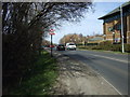
Moss Way
Heading north past Moss Way Police Station.
Image: © JThomas
Taken: 7 Mar 2015
0.20 miles
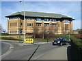
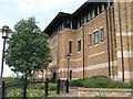
6

Moss Way police station
Large, modern police station serving the Mosborough area of the city.
Image: © Graham Hogg
Taken: 28 Aug 2012
0.21 miles
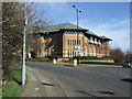
10
Police Station, Mosborough
Close to Crystal Peaks is the new police station which replaced the old Hackenthorpe nick.
Image: © David Morris
Taken: 1 Jul 2006
0.22 miles