IMAGES TAKEN NEAR TO
Sloade Lane, SHEFFIELD, S12 3YA
Introduction
This page details the photographs taken nearby to Sloade Lane, S12 3YA by members of the Geograph project.
The Geograph project started in 2005 with the aim of publishing, organising and preserving representative images for every square kilometre of Great Britain, Ireland and the Isle of Man.

There are currently over 7.5m images from over14,400 individuals and you can help contribute to the project by visiting https://www.geograph.org.uk
Image Map
Images are licensed for reuse under creativecommons.org/licenses/by-sa/2.0
Notes
- Clicking on the map will re-center to the selected point.
- The higher the marker number, the further away the image location is from the centre of the postcode.
Image Listing (31 Images Found)
Images are licensed for reuse under creativecommons.org/licenses/by-sa/2.0
Image
Details
Distance
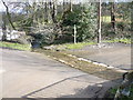
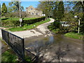
1
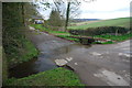
Ford at Ridgeway Moor
This ford on the Robin Brook is found at the foot of Sloade Lane at the approach to Dowland Farm.
Image: © John Walton
Taken: 27 Apr 2013
0.03 miles
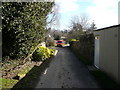
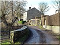
4
Sloade Lane - House on a Hill with Sheep
Image: © Alan Heardman
Taken: 2 Mar 2007
0.07 miles
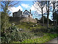
5
Gateway to "The Orchards", Sloade Lane, Ridgeway
Image: © Neil Theasby
Taken: 21 Sep 2011
0.08 miles
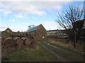
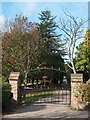
7
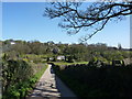
Lane from Litfield Farm
Farmland between Ridgeway Moor and Ford, south of Sheffield.
Image: © Peter Barr
Taken: 8 Apr 2011
0.09 miles