IMAGES TAKEN NEAR TO
High Lane, SHEFFIELD, S12 3XF
Introduction
This page details the photographs taken nearby to High Lane, S12 3XF by members of the Geograph project.
The Geograph project started in 2005 with the aim of publishing, organising and preserving representative images for every square kilometre of Great Britain, Ireland and the Isle of Man.

There are currently over 7.5m images from over14,400 individuals and you can help contribute to the project by visiting https://www.geograph.org.uk
Image Map
Images are licensed for reuse under creativecommons.org/licenses/by-sa/2.0
Notes
- Clicking on the map will re-center to the selected point.
- The higher the marker number, the further away the image location is from the centre of the postcode.
Image Listing (14 Images Found)
Images are licensed for reuse under creativecommons.org/licenses/by-sa/2.0
Image
Details
Distance
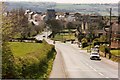
1
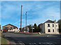
Highlane - B6045 junction with the Main Road to Ridgeway
Image: © Neil Theasby
Taken: 21 Sep 2011
0.03 miles
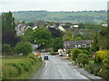
2
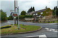
Road junction at Highlane
High Lane, the B6388, crosses the top of the hillside and Main Road heads left down through Ridgeway.
Image: © Andrew Hill
Taken: 30 May 2011
0.04 miles
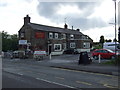
5
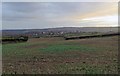
Overlooking Ridgeway village
Looking down the hill from near the top at Highlane. All the foreground in the picture and the village to the middle distance is in square, but the viewpoint is a bit further up the beyond the gridline.
Image: © Andrew Hill
Taken: 30 May 2011
0.15 miles
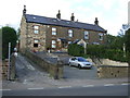
7
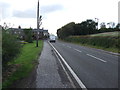
High Lane (B6388)
Heading north west towards Sheffield.
Image: © JThomas
Taken: 28 Aug 2014
0.16 miles
8
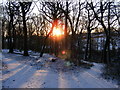
Birley Wood
Remains of ancient woodland.
Image: © IAIN BARKER
Taken: 3 Jan 2010
0.18 miles
9
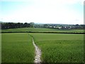
Approaching Ridgeway from Haven Farm
Public footpath crossing a wheat field which was cracked underfoot following a prolongued dry spell.
Image: © Jonathan Clitheroe
Taken: 22 May 2011
0.18 miles