IMAGES TAKEN NEAR TO
Jaunty Drive, SHEFFIELD, S12 3DH
Introduction
This page details the photographs taken nearby to Jaunty Drive, S12 3DH by members of the Geograph project.
The Geograph project started in 2005 with the aim of publishing, organising and preserving representative images for every square kilometre of Great Britain, Ireland and the Isle of Man.

There are currently over 7.5m images from over14,400 individuals and you can help contribute to the project by visiting https://www.geograph.org.uk
Image Map
Images are licensed for reuse under creativecommons.org/licenses/by-sa/2.0
Notes
- Clicking on the map will re-center to the selected point.
- The higher the marker number, the further away the image location is from the centre of the postcode.
Image Listing (2 Images Found)
Images are licensed for reuse under creativecommons.org/licenses/by-sa/2.0
Image
Details
Distance
1
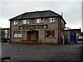
The Centre Spot
The forbidding aspect of this estate pub is not helped by the grey January weather.
Image: © Graham Hogg
Taken: 13 Jan 2011
0.12 miles
2
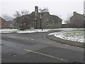
St Peter's
This church by the side of the appropriately named White Lane is dedicated to St Peter.
Image: © Michael Patterson
Taken: 9 Feb 2007
0.23 miles