IMAGES TAKEN NEAR TO
Foxfield Close, SHEFFIELD, S12 3BT
Introduction
This page details the photographs taken nearby to Foxfield Close, S12 3BT by members of the Geograph project.
The Geograph project started in 2005 with the aim of publishing, organising and preserving representative images for every square kilometre of Great Britain, Ireland and the Isle of Man.

There are currently over 7.5m images from over14,400 individuals and you can help contribute to the project by visiting https://www.geograph.org.uk
Image Map
Images are licensed for reuse under creativecommons.org/licenses/by-sa/2.0
Notes
- Clicking on the map will re-center to the selected point.
- The higher the marker number, the further away the image location is from the centre of the postcode.
Image Listing (20 Images Found)
Images are licensed for reuse under creativecommons.org/licenses/by-sa/2.0
Image
Details
Distance

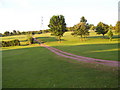
9
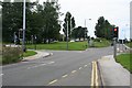
Tram crossing / road junction, Birley Lane
To the left is Birley Lane. To the right is Sheffield Road. Straight on up is Birley Moor Road and down behind me is Moor Valley. The tram route to the right heads towards Crystal Peaks and the ultimate terminus at Halfway. To the left (west) it heads up past Birley Golf Course, on to the Manor Top and down into Sheffield.
Image: © David Morris
Taken: 26 Aug 2006
0.13 miles