IMAGES TAKEN NEAR TO
Bartle Way, SHEFFIELD, S12 2QS
Introduction
This page details the photographs taken nearby to Bartle Way, S12 2QS by members of the Geograph project.
The Geograph project started in 2005 with the aim of publishing, organising and preserving representative images for every square kilometre of Great Britain, Ireland and the Isle of Man.

There are currently over 7.5m images from over14,400 individuals and you can help contribute to the project by visiting https://www.geograph.org.uk
Image Map
Images are licensed for reuse under creativecommons.org/licenses/by-sa/2.0
Notes
- Clicking on the map will re-center to the selected point.
- The higher the marker number, the further away the image location is from the centre of the postcode.
Image Listing (9 Images Found)
Images are licensed for reuse under creativecommons.org/licenses/by-sa/2.0
Image
Details
Distance


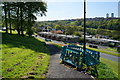
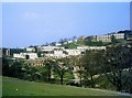
3
Gleadless Bank
This picture was taken on an increasingly rain-threatened afternoon in mid May.
Image: © Jonathan Clitheroe
Taken: 13 May 2011
0.18 miles

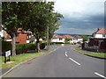
5
Path leading to Fleury Road
Gleadless Valley, Sheffield.
Image: © Ian S
Taken: 3 May 2014
0.22 miles
6
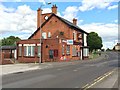
Heeley and Sheffield
Closed pub on Gleadless Road
Image: © David Lally
Taken: 21 Jun 2015
0.23 miles
7

The Heeley & Sheffield, Public House
On Gleadless Road.
Image: © JThomas
Taken: 28 Aug 2014
0.23 miles
8
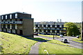
Rollestone Gleadless Housing, Sheffield, 1965
At the time Sheffield was considered to be a leader of well-designed housing replacing its typical Victorian terraces. The picture was taken in the course of a student study tour to a number of new housing locations in the City.
Image: © Alan Murray-Rust
Taken: 2 Apr 1965
0.24 miles