IMAGES TAKEN NEAR TO
Alnwick Road, SHEFFIELD, S12 2GG

Introduction

This page details the photographs taken nearby to Alnwick Road, S12 2GG by members of the Geograph project.

The Geograph project started in 2005 with the aim of publishing, organising and preserving representative images for every square kilometre of Great Britain, Ireland and the Isle of Man.

There are currently over 7.5m images from over14,400 individuals and you can help contribute to the project by visiting https://www.geograph.org.uk

Image Map


Images are licensed for reuse under creativecommons.org/licenses/by-sa/2.0
Notes
  • Clicking on the map will re-center to the selected point.
  • The higher the marker number, the further away the image location is from the centre of the postcode.

Image Listing (14 Images Found)

Images are licensed for reuse under creativecommons.org/licenses/by-sa/2.0
Image
Details
Distance
1
Supertram on Sheffield's ring road near Gleadless
Image: © Steve Fareham Taken: 31 Jan 2009
0.12 miles
2
Ridgeway Road
This is the view down Ridgeway Road. Behind me is the Manor Top and Elm Tree. Here, the trams run down the central reservation, hence the overhead line work.
Image: © David Morris Taken: 26 Aug 2006
0.16 miles
3
Hollinsend Park
Park and sports ground which was opened in 1932. The chimney of Gleadless Primary School is visible towards the right of the picture.
Image: © Jonathan Clitheroe Taken: 23 Sep 2010
0.17 miles
4
Newlands Drive, Intake
Image: © Richard Vince Taken: 10 Jul 2013
0.19 miles
5
Number Two Green, Hollinsend Park Bowling Club, Hollinsend Park, Sheffield
Image: © Terry Robinson Taken: 20 Aug 2012
0.23 miles
6
Newlands Avenue
Image: © Martin Speck Taken: 5 Aug 2010
0.24 miles
7
Hollinsend Park and Bowling Club Disabled Parking, Hollinsend Park, Sheffield
Image: © Terry Robinson Taken: 20 Aug 2012
0.24 miles
8
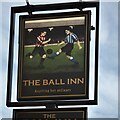
The sign of The Ball Inn
See Image Depiction a Sheffield derby match it would seem. With the players in the colours of Sheffield United (red) on the left and Sheffield Wednesday (blue) on the right.
Image: © David Lally Taken: 8 Feb 2023
0.24 miles
9
The Ball Inn
Mansfield Road, Intake. I find it harder to identify the former brewery from the pub architecture in Sheffield than in Nottingham. However, my guess would be that this was formerly a Tetley's establishment built in the between war period.
Image: © David Lally Taken: 8 Feb 2023
0.25 miles
10
Hollinsend Park Bowling Club House, Hollinsend Park, Sheffield
On this lovely sunny evening Hollinsend Bowling Club were playing a match against the Stocksbridge Friendship Club. See also ... Image Image Image Image Image Image Image Image Image
Image: © Terry Robinson Taken: 20 Aug 2012
0.25 miles