IMAGES TAKEN NEAR TO
Sharrard Drive, SHEFFIELD, S12 2FB
Introduction
This page details the photographs taken nearby to Sharrard Drive, S12 2FB by members of the Geograph project.
The Geograph project started in 2005 with the aim of publishing, organising and preserving representative images for every square kilometre of Great Britain, Ireland and the Isle of Man.

There are currently over 7.5m images from over14,400 individuals and you can help contribute to the project by visiting https://www.geograph.org.uk
Image Map
Images are licensed for reuse under creativecommons.org/licenses/by-sa/2.0
Notes
- Clicking on the map will re-center to the selected point.
- The higher the marker number, the further away the image location is from the centre of the postcode.
Image Listing (7 Images Found)
Images are licensed for reuse under creativecommons.org/licenses/by-sa/2.0
Image
Details
Distance
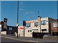
2
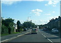
"Men Zone" Hairdressing Salon, Mansfield Road, Sheffield
Image: © Neil Theasby
Taken: 1 Sep 2011
0.17 miles
3
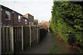
Path beside Intake Cemetery
The cemetery is hidden by the large leylandii hedge. On the left is the rear of the houses on Mansfield Drive.
Image: © David Lally
Taken: 8 Feb 2023
0.17 miles
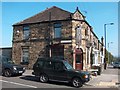
4
"Embassy" club and "Foxwood Inn", Mansfield Road, Sheffield
Image: © Neil Theasby
Taken: 1 Sep 2011
0.22 miles
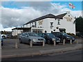
6
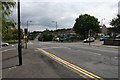
Hollins End / Four Lanes End
This is the junction of Hollins End Road (to the right - SW), Hollybank Road (left - NE) and Mansfield Road (SE - NW). I'm standing outside the Co-op, but once on this junction stood the Rex Cinema and a Workingmen's club. I think the former is occupied by the Co-op and the latter by a nursing home.
Image: © David Morris
Taken: 26 Aug 2006
0.24 miles
7
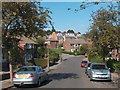
Looking down Pleasant Road towards Little Lane, Intake, Sheffield
Image: © Neil Theasby
Taken: 1 Sep 2011
0.24 miles