IMAGES TAKEN NEAR TO
Moorbank Road, SHEFFIELD, S10 5TR
Introduction
This page details the photographs taken nearby to Moorbank Road, S10 5TR by members of the Geograph project.
The Geograph project started in 2005 with the aim of publishing, organising and preserving representative images for every square kilometre of Great Britain, Ireland and the Isle of Man.

There are currently over 7.5m images from over14,400 individuals and you can help contribute to the project by visiting https://www.geograph.org.uk
Image Map
Images are licensed for reuse under creativecommons.org/licenses/by-sa/2.0
Notes
- Clicking on the map will re-center to the selected point.
- The higher the marker number, the further away the image location is from the centre of the postcode.
Image Listing (25 Images Found)
Images are licensed for reuse under creativecommons.org/licenses/by-sa/2.0
Image
Details
Distance
1
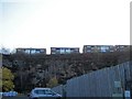
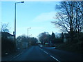
Valleyside Garden Centre Car Park, Manchester Road, Sheffield
This picture shows the steep sides of the former Bell Hagg Quarry. The apartments are on Moorbank Drive. Image Image
Image: © Terry Robinson
Taken: 16 Nov 2008
0.04 miles
2
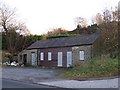
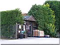
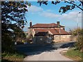
Mystery Building, Manchester Road, Sheffield
This building is close to the Valleyside Garden Centre, opposite the Bell Hagg Inn ... but I have no idea what it is/was used for. If you know ... please let me know!
Image: © Terry Robinson
Taken: 16 Nov 2008
0.06 miles
3
Valleyside Garden Centre, Manchester Road, Sheffield
Image: © Terry Robinson
Taken: 16 Nov 2008
0.07 miles
4

Sunday Morning at Bell Hagg ... Can You Ride Tandem?
Image: © Terry Robinson
Taken: 25 Jan 2009
0.07 miles
5
Bell Hagg Inn - 3, Manchester Road, Sheffield
Image: © Terry Robinson
Taken: 16 Nov 2008
0.07 miles
7
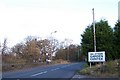
Valleyside Garden Centre Entrance, Manchester Road, Sheffield
The Garden Centre is situated in what was formerly Bell Hagg Quarry and is opposite the Bell Hagg Inn. Image Image
Image: © Terry Robinson
Taken: 16 Nov 2008
0.08 miles
8
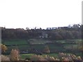
Bell Hagg Inn from Tofts Lane, Rivelin, Sheffield
This view of the (now derelict) Bell Hagg Inn shows the five storeys of the building ... it seems to 'tumble down' the hillside. The apartments above it, on the skyline, are on Moorbank Road. The valley in front is the Rivelin Valley with the Rivelin River flowing right to left to meet up with the River Loxley at Malin Bridge ... the River Loxley then meets the River Don and on, and on, and on ... Image
Image: © Terry Robinson
Taken: 16 Nov 2008
0.09 miles
9
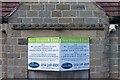
Bell Hagg Inn For Sale, Manchester Road, Sheffield
The sign above the door shows the dates 1832 - 2000 ... shame that before the decade is over the pub is closed. I believe that this pub had the best 'supping views' in all of Sheffield! Image Image Image
Image: © Terry Robinson
Taken: 16 Nov 2008
0.09 miles
10
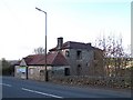
The sadly neglected "Bell Hagg Inn" on Manchester Road, Sheffield
I remember this chiefly as a pub with a wonderful view over the Rivelin Valley. It served splendid Sunday lunches and there were folk evenings and quiz nights. Built into the steep valley side, the inn had five floors. It was erected in 1832 and was originally known as "Hodgson's Folly". Yet another in the long list of traditional English pubs that have closed their doors forever.
Image: © Neil Theasby
Taken: 11 Oct 2010
0.09 miles