IMAGES TAKEN NEAR TO
Bell Hagg, SHEFFIELD, S10 5PX
Introduction
This page details the photographs taken nearby to Bell Hagg, S10 5PX by members of the Geograph project.
The Geograph project started in 2005 with the aim of publishing, organising and preserving representative images for every square kilometre of Great Britain, Ireland and the Isle of Man.

There are currently over 7.5m images from over14,400 individuals and you can help contribute to the project by visiting https://www.geograph.org.uk
Image Map
Images are licensed for reuse under creativecommons.org/licenses/by-sa/2.0
Notes
- Clicking on the map will re-center to the selected point.
- The higher the marker number, the further away the image location is from the centre of the postcode.
Image Listing (50 Images Found)
Images are licensed for reuse under creativecommons.org/licenses/by-sa/2.0
Image
Details
Distance
1
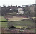
Former Bell Hagg Inn, Manchester Road, Sheffield
A photograph taken from near The Rivelin Hotel, Roscoe Bank (< road name) with a view of the rear of the former Bell Hagg Inn on the northern side of the A57 (the Sheffield to Manchester Road). The pub finally closed in 2005 and has now been converted into a seven-bedroom family home. It is believed that the original building was erected in 1832 as a five-storey house for a certain Dr Hodgeson who had built it as a folly to antagonise the Vicar of Stannington after the incumbent turned down his offer of a generous donation because Hodgeson had made much of his fortune from gambling. Before becoming a pub the building was used as a tea room by workers associated with a former quarry on the opposite of its front elevation (that is now occupied by the Valleyside Garden Centre), and also by travellers between these two northern cities. The houses in the background are situated in Moorbank Court, Crosspool.
Image: © David Hallam-Jones
Taken: 18 Feb 2018
0.06 miles
2
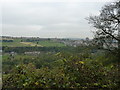
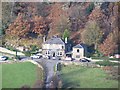
The view from the back of the Bell Hagg
Across the Rivelin Valley towards Stannington.
Image: © Peter Barr
Taken: 12 Oct 2010
0.09 miles
3
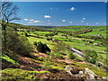
Rivelin Valley
The Rivelin Valley viewed from the crags above Bell Hagg. The road is the A57, which eventually becomes the Snake Pass. http://www.rivelinvalley.org.uk/
Image: © Roger Butterfield
Taken: 5 May 2006
0.10 miles
4
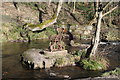
Chair in the river!
A sculpture chair in the River Loxley.
Image: © Dave Pickersgill
Taken: 1 Feb 2018
0.12 miles
5
Rivelin Valley Road.
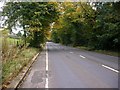
A view of the Rivelin Valley Road (A6101) which links the A57 Sheffield-Manchester road with the Hillsborough area to the north of Sheffield. The view is looking east towards Hillsborough.
Image: © Brian Ward
Taken: 18 Oct 2006
0.13 miles
7
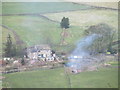
Model Farm, Under Tofts, Rivelin Valley, Sheffield
Is this where all the models are grown?
Image: © Terry Robinson
Taken: 16 Nov 2008
0.13 miles
8
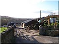
The Rivelin Inn from Bell Hagg, Rivelin Valley, Sheffield
This view shows the crags immediately behind the pub and part of the very steep road leading up to the pub from Rivelin Valley Road.
Image: © Terry Robinson
Taken: 16 Nov 2008
0.16 miles
9
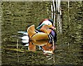
Mandarin duck in The Rivelin Valley
Spotted in Hind Wheel mill dam. The first mandarins were imported to Britain in the mid-18th century, but it wasn't until the 1930s that escapees from wildfowl collections started breeding here. Now it is estimated that our wild population may be around 7000.
Image: © Neil Theasby
Taken: 10 Apr 2023
0.16 miles
10
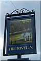
The Rivelin Pub Sign, Tofts Lane, Rivelin Valley, Sheffield
Image: © Terry Robinson
Taken: 2 Mar 2009
0.16 miles