IMAGES TAKEN NEAR TO
Vernon Delph, SHEFFIELD, S10 5NS
Introduction
This page details the photographs taken nearby to Vernon Delph, S10 5NS by members of the Geograph project.
The Geograph project started in 2005 with the aim of publishing, organising and preserving representative images for every square kilometre of Great Britain, Ireland and the Isle of Man.

There are currently over 7.5m images from over14,400 individuals and you can help contribute to the project by visiting https://www.geograph.org.uk
Image Map
Images are licensed for reuse under creativecommons.org/licenses/by-sa/2.0
Notes
- Clicking on the map will re-center to the selected point.
- The higher the marker number, the further away the image location is from the centre of the postcode.
Image Listing (28 Images Found)
Images are licensed for reuse under creativecommons.org/licenses/by-sa/2.0
Image
Details
Distance
2
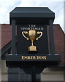
Sign for the Sportsman public house, Sheffield
An Ember Inn on Benty Lane.
Image: © JThomas
Taken: 13 Jun 2018
0.11 miles
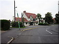
4
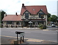
The Sportsman public house, Sheffield
An Ember Inn on Benty Lane.
Image: © JThomas
Taken: 13 Jun 2018
0.12 miles
5
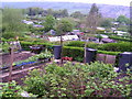
Allotments
Overlooking the Rivelin valley
Image: © N Chadwick
Taken: 13 May 2006
0.14 miles
6
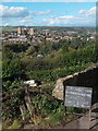
Entrance to Hagg Lane Allotments looking towards Stannington
Image: © Neil Theasby
Taken: 6 Oct 2010
0.15 miles
7
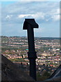
Hagg Lane Allotments - chimney with a view
Image: © Neil Theasby
Taken: 6 Oct 2010
0.16 miles
8
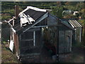
Allotment construction off Hagg Lane, Sheffield
Image: © Neil Theasby
Taken: 6 Oct 2010
0.16 miles
9
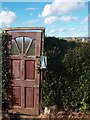
The entrance to Allotment No. 20, Hagg Lane Allotments
Image: © Neil Theasby
Taken: 6 Oct 2010
0.16 miles
10
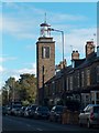
Manchester Road, Crosspool with a view of St Columba's lighthouse-like church tower
Image: © Neil Theasby
Taken: 6 Oct 2010
0.17 miles