IMAGES TAKEN NEAR TO
Lawson Road, SHEFFIELD, S10 5BU
Introduction
This page details the photographs taken nearby to Lawson Road, S10 5BU by members of the Geograph project.
The Geograph project started in 2005 with the aim of publishing, organising and preserving representative images for every square kilometre of Great Britain, Ireland and the Isle of Man.

There are currently over 7.5m images from over14,400 individuals and you can help contribute to the project by visiting https://www.geograph.org.uk
Image Map
Images are licensed for reuse under creativecommons.org/licenses/by-sa/2.0
Notes
- Clicking on the map will re-center to the selected point.
- The higher the marker number, the further away the image location is from the centre of the postcode.
Image Listing (167 Images Found)
Images are licensed for reuse under creativecommons.org/licenses/by-sa/2.0
Image
Details
Distance
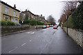
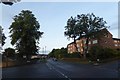
5
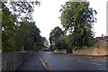
Tapton House Road
Looking along Tapton House Road near the junction with Tapton Crescent Road.
Image: © DS Pugh
Taken: 23 Aug 2018
0.11 miles
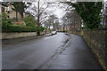
7
Along Tapton House Road
Looking along a street in the Tapton Hill area of Sheffield.
Image: © DS Pugh
Taken: 23 Aug 2018
0.12 miles
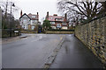
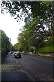
8
Taptonville Road, Sheffield
Typical leafy suburban street in the Broomhill area.
Image: © Stephen McKay
Taken: 25 Feb 2007
0.13 miles
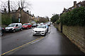
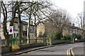
9
Tapton House Road
Looking along Tapton Crescent Road at the junction with Tapton High Road (left) and Ryegate Road (right).
Image: © DS Pugh
Taken: 23 Aug 2018
0.13 miles
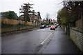
10
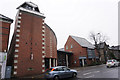
The Beacon Methodist Church, Broomhill, Sheffield
Image: © Ian S
Taken: 20 Jan 2018
0.13 miles