IMAGES TAKEN NEAR TO
Hawthorne Mews, SHEFFIELD, S10 5AD
Introduction
This page details the photographs taken nearby to Hawthorne Mews, S10 5AD by members of the Geograph project.
The Geograph project started in 2005 with the aim of publishing, organising and preserving representative images for every square kilometre of Great Britain, Ireland and the Isle of Man.

There are currently over 7.5m images from over14,400 individuals and you can help contribute to the project by visiting https://www.geograph.org.uk
Image Map (Loading...)


Getting Data...Please wait
Leaflet Map data © OpenStreetMap
Images are licensed for reuse under creativecommons.org/licenses/by-sa/2.0
Notes
- Clicking on the map will re-center to the selected point.
- The higher the marker number, the further away the image location is from the centre of the postcode.
Image Listing (195 Images Found)
Images are licensed for reuse under creativecommons.org/licenses/by-sa/2.0
Image
Details
Distance
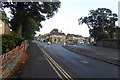
5

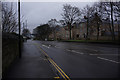
Weston View junction with Crookes Road Sheffield
Image: © Steve Fareham
Taken: 3 Aug 2015
0.04 miles
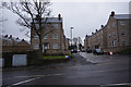
6
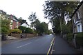
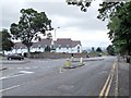
Crookes Road
Looking along Crookes Road near Crookesmoor Road.
Image: © DS Pugh
Taken: 23 Aug 2018
0.06 miles
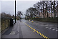
7
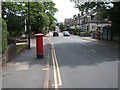
Crookes Road, Sheffield
Showing position of Postbox No. S10 263.
See Image] for postbox.
Image: © JThomas
Taken: 13 Jun 2018
0.06 miles
8
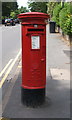
Elizabeth II postbox on Crookes Road, Sheffield
Postbox No. S10 263.
See Image] for context.
Image: © JThomas
Taken: 13 Jun 2018
0.07 miles
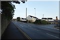
9
Lydgate Lane, Crookes
This is the junction of Lydgate Lane, Crookes and Crookes Road. Years ago, just out of sight and to the left of the picture, was a clump of early 19th century (at least) cottages and a pub; all gone by the ‘70s.
Over the wall where the new build is, there was nothing of note that I can remember. An 1894 map shows a small building at the other side of the wall, which may have been some sort of store/maintenance shed; after all, there is a sizeable quantity of grass to mow. Beyond the new build was/is an underground reservoir. Whether this is still in use or not, I have yet to find out.
The above ground was utilised for sports, such as cricket and football. It may still be in use. Back in 1855, this reservoir was called Pisgah Dam, but since 1893, Hadfield Dam. The name may have been in use much earlier, but I have no evidence to back that up.
The monolith in the distance is the Sheffield University Arts Tower.
Image: © Dave Hitchborne
Taken: 26 Aug 2008
0.07 miles