IMAGES TAKEN NEAR TO
Andwell Lane, SHEFFIELD, S10 4QF
Introduction
This page details the photographs taken nearby to Andwell Lane, S10 4QF by members of the Geograph project.
The Geograph project started in 2005 with the aim of publishing, organising and preserving representative images for every square kilometre of Great Britain, Ireland and the Isle of Man.

There are currently over 7.5m images from over14,400 individuals and you can help contribute to the project by visiting https://www.geograph.org.uk
Image Map
Images are licensed for reuse under creativecommons.org/licenses/by-sa/2.0
Notes
- Clicking on the map will re-center to the selected point.
- The higher the marker number, the further away the image location is from the centre of the postcode.
Image Listing (53 Images Found)
Images are licensed for reuse under creativecommons.org/licenses/by-sa/2.0
Image
Details
Distance
1

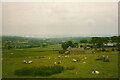
Cottages, Fulwood Lane, Sheffield
With a splendid view over the Mayfield Valley and Fulwood.
Image: © Graham Hogg
Taken: 4 Sep 2010
0.01 miles
2

Clouds over Suburbia
Looking from Fulwood Lane over Bassett Cottages towards one of Sheffield's western suburbs - Fulwood.
Image: © Neil Theasby
Taken: 4 Feb 2018
0.01 miles
3
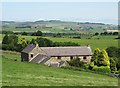
Bassett Cottages from Fulwood Lane, near Ringinglow
Image: © Humphrey Bolton
Taken: 7 Jul 1999
0.02 miles
4
Bassett Cottages with view towards The Loxley Valley
Image: © Neil Theasby
Taken: 15 Jul 2015
0.02 miles
5
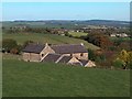
Bassett Cottages seen from Fulwood Lane
Image: © Neil Theasby
Taken: 20 Oct 2010
0.02 miles
6

Bassett Cottages off Fulwood Lane
Looking north to Lodge Moor and The Loxley Valley
Image: © Neil Theasby
Taken: 4 Feb 2018
0.02 miles
7
Bassett, Sheffield
This is taken from Fulwood lane on the edge of the moors. Behind Bassett is Green House Farm, then the long, long slope down to Sheffield.
Image: © Humphrey Bolton
Taken: 7 Jul 1999
0.03 miles
8
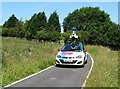
Google Streetview Vehicle on Bassett Lane
Collecting yet more images to refresh Google's Streetview service. In the course of time, this may well now include a wandering geograph member in the country lanes to the south west of Sheffield.
Image: © Neil Theasby
Taken: 15 Jul 2015
0.05 miles
9
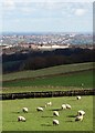
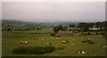
Sheep and school view - High Storrs
The sheep are grazing between Fulwood and Ringinglow and the illuminated school building is High Storrs Secondary School in the Bents Green/Ecclesall suburb of Sheffield.
Image: © Neil Theasby
Taken: 20 Feb 2014
0.07 miles
10
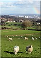
Sheep above Sheffield
They are grazing by Bassett Lane. In the valley there's the ghost of a half-formed rainbow.
Image: © Neil Theasby
Taken: 20 Feb 2014
0.08 miles