IMAGES TAKEN NEAR TO
Kensington Park, SHEFFIELD, S10 4NJ
Introduction
This page details the photographs taken nearby to Kensington Park, S10 4NJ by members of the Geograph project.
The Geograph project started in 2005 with the aim of publishing, organising and preserving representative images for every square kilometre of Great Britain, Ireland and the Isle of Man.

There are currently over 7.5m images from over14,400 individuals and you can help contribute to the project by visiting https://www.geograph.org.uk
Image Map
Images are licensed for reuse under creativecommons.org/licenses/by-sa/2.0
Notes
- Clicking on the map will re-center to the selected point.
- The higher the marker number, the further away the image location is from the centre of the postcode.
Image Listing (25 Images Found)
Images are licensed for reuse under creativecommons.org/licenses/by-sa/2.0
Image
Details
Distance
1
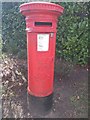
Edward VII Postbox
Outside the entrance to the former Lodge Moor Hospital (now a housing estate)
Image: © Keith Pitchforth
Taken: 5 Apr 2020
0.10 miles
2
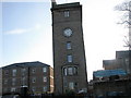
Converted clock tower
The Lodge Moor Hospital buildings have been demolished to make way for a residential estate known as Redmires Close and all that remains from the past is this tower which would appear to have been converted into flats.
Image: © Roger Temple
Taken: 27 Jan 2007
0.11 miles
3
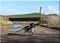
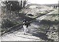
Dog with a very big stick
In the little car park by the playground off Lodge Moor Lane
Image: © Neil Theasby
Taken: 7 Mar 2014
0.11 miles
4
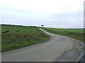
Lodge Moor Road
A view looking south along Lodge Moor Road from where it is crossed by an open water conduit from Redmires Reservoirs.
Image: © Brian Ward
Taken: 25 Oct 2006
0.11 miles
5
Dog with a log
On the footpath that leads from Lodge Moor Lane to Redmires Reservoirs
Image: © Neil Theasby
Taken: 7 Mar 2014
0.11 miles
6
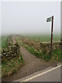
Path by the Redmires Conduit
The picture is taken where the path crosses Lodge Moore Roar, looking back towards Sheffield. The brown vegetation to the right of the path hides the open conduit.
The conduit was built to carry clean water from the Redmires reservoirs on the edge of Sheffield to reservoirs in Crookes Valley closer to the centre of the city following the devastating cholera epidemic of 1832. The first part comprises an open water conduit (as shown in the photo) before going underground.
Image: © Richard Rogerson
Taken: 31 Mar 2024
0.12 miles
7
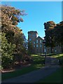
Lodge Moor Hospital Tower
Lodge Moor Hospital was built in the 1880's and for over a hundred years it served the people of Sheffield - sometimes known as "The Fever Hospital". Its construction on the edge of the city close to windy moors reflects a Victorian belief that fresh air was helpful for recuperation from illness. The hospital site is now home to a large private housing estate.
Image: © Neil Theasby
Taken: 20 Oct 2010
0.14 miles
8
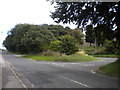
Bus turning circle, Lodge Moor
Located on Redmires Road just west of where the houses stop, this is the terminus of First Sheffield route 51 from Charnock via Sheffield city centre.
Image: © Richard Vince
Taken: 31 Aug 2013
0.16 miles
9
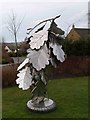
Great oaks from little acorns grow
Stainless steel sculpture at the entrance to an upmarket housing estate on the former Lodge Moor hospital site.
Image: © Steve Fareham
Taken: 13 Mar 2008
0.18 miles
10
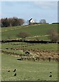
View across fields to the tower house on Blackbrook Road
Image: © Neil Theasby
Taken: 7 Mar 2014
0.18 miles