IMAGES TAKEN NEAR TO
Castlewood Road, SHEFFIELD, S10 4FG
Introduction
This page details the photographs taken nearby to Castlewood Road, S10 4FG by members of the Geograph project.
The Geograph project started in 2005 with the aim of publishing, organising and preserving representative images for every square kilometre of Great Britain, Ireland and the Isle of Man.

There are currently over 7.5m images from over14,400 individuals and you can help contribute to the project by visiting https://www.geograph.org.uk
Image Map
Images are licensed for reuse under creativecommons.org/licenses/by-sa/2.0
Notes
- Clicking on the map will re-center to the selected point.
- The higher the marker number, the further away the image location is from the centre of the postcode.
Image Listing (14 Images Found)
Images are licensed for reuse under creativecommons.org/licenses/by-sa/2.0
Image
Details
Distance
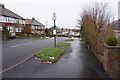
1
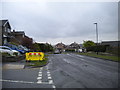
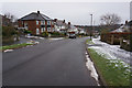
Crimicar Lane, Sheffield
Looking down Crimicar Lane from the corner of Moorcroft Road
Image: © Nick Morris
Taken: 14 Apr 2015
0.10 miles
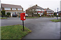
2
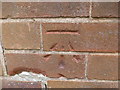
Cut Mark 152 Crimicar Lane Sheffield
as above
Image: © Monica Stagg
Taken: 25 Feb 2015
0.16 miles
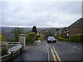
3
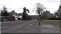
Brooklands Drive off Brooklands Avenue, Sheffield
Image: © Ian S
Taken: 20 Jan 2018
0.18 miles
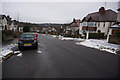
5
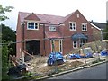
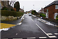
Building site on Canterbury Avenue
An executive style building on a single plot of land on Canterbury Avenue.
Image: © Martin Speck
Taken: 11 Jul 2009
0.20 miles