IMAGES TAKEN NEAR TO
St. Albans Drive, SHEFFIELD, S10 4DL
Introduction
This page details the photographs taken nearby to St. Albans Drive, S10 4DL by members of the Geograph project.
The Geograph project started in 2005 with the aim of publishing, organising and preserving representative images for every square kilometre of Great Britain, Ireland and the Isle of Man.

There are currently over 7.5m images from over14,400 individuals and you can help contribute to the project by visiting https://www.geograph.org.uk
Image Map (Loading...)


Getting Data...Please wait
Leaflet Map data © OpenStreetMap
Images are licensed for reuse under creativecommons.org/licenses/by-sa/2.0
Notes
- Clicking on the map will re-center to the selected point.
- The higher the marker number, the further away the image location is from the centre of the postcode.
Image Listing (17 Images Found)
Images are licensed for reuse under creativecommons.org/licenses/by-sa/2.0
Image
Details
Distance
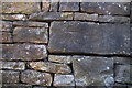
8
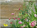
Cut Mark Outbuilding junction Hallam Grange Cres Sheffield
Image: © Monica Stagg
Taken: 28 Jun 2015
0.17 miles
9
Cut Mark on the wall of 5 Hallam Grange Road
Image: © Keith Pitchforth
Taken: 22 Mar 2020
0.18 miles
10
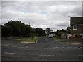
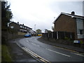
Winchester Road, Fulwood
A residential Road off Crimicar Lane (foreground).
Image: © Richard Vince
Taken: 31 Aug 2013
0.22 miles