IMAGES TAKEN NEAR TO
Chorley Road, SHEFFIELD, S10 3RN
Introduction
This page details the photographs taken nearby to Chorley Road, S10 3RN by members of the Geograph project.
The Geograph project started in 2005 with the aim of publishing, organising and preserving representative images for every square kilometre of Great Britain, Ireland and the Isle of Man.

There are currently over 7.5m images from over14,400 individuals and you can help contribute to the project by visiting https://www.geograph.org.uk
Image Map
Images are licensed for reuse under creativecommons.org/licenses/by-sa/2.0
Notes
- Clicking on the map will re-center to the selected point.
- The higher the marker number, the further away the image location is from the centre of the postcode.
Image Listing (43 Images Found)
Images are licensed for reuse under creativecommons.org/licenses/by-sa/2.0
Image
Details
Distance
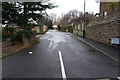
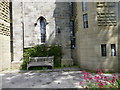
1
Steps to Christ Church Graveyard
Fulwood, Sheffield.
Image: © Ian S
Taken: 20 Jan 2018
0.00 miles
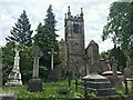
3
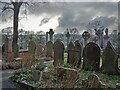
The churchyard at Christ Church, Fulwood
Image: © Neil Theasby
Taken: 5 Feb 2021
0.04 miles
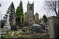
5
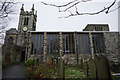
Christ Church, Fulwood
A grade II listed parish church built in 1837-39
Image: © Graham Hogg
Taken: 19 Jun 2019
0.05 miles
6
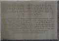
Fulwood Parish War Memorial Plaque
Christ Church, Fulwood, Sheffield.
Image: © Ian S
Taken: 20 Jan 2018
0.05 miles
8
Christ Church Fulwood Sheffield (Tower)
Image: © Monica Stagg
Taken: 28 Jun 2015
0.05 miles
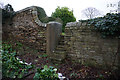
9
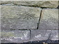
Cut Mark Wall 2 Oriel Road Fulwood Sheffield
Image: © Monica Stagg
Taken: 28 Jun 2015
0.05 miles