IMAGES TAKEN NEAR TO
Carsick Hill Crescent, SHEFFIELD, S10 3LT
Introduction
This page details the photographs taken nearby to Carsick Hill Crescent, S10 3LT by members of the Geograph project.
The Geograph project started in 2005 with the aim of publishing, organising and preserving representative images for every square kilometre of Great Britain, Ireland and the Isle of Man.

There are currently over 7.5m images from over14,400 individuals and you can help contribute to the project by visiting https://www.geograph.org.uk
Image Map
Images are licensed for reuse under creativecommons.org/licenses/by-sa/2.0
Notes
- Clicking on the map will re-center to the selected point.
- The higher the marker number, the further away the image location is from the centre of the postcode.
Image Listing (13 Images Found)
Images are licensed for reuse under creativecommons.org/licenses/by-sa/2.0
Image
Details
Distance
2
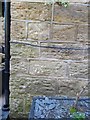
Bench Mark
This Bench Mark (also referred to as a cut mark) is on the wall of the cottage on the corner of Carsick Hill Road and Snaithing Lane
Image: © Keith Pitchforth
Taken: 14 Apr 2020
0.12 miles
3
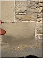
Bench Mark
This Bench Mark (also referred to as a cut mark) is on the wall opposite Snaithing Lane at its junction with Carsick Hill Road and
Image: © Keith Pitchforth
Taken: 14 Apr 2020
0.13 miles
4
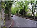
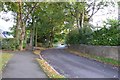
Snaithing Park Road
The street ascends Carsick Hill.
Image: © DS Pugh
Taken: 24 Aug 2018
0.14 miles
5
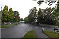
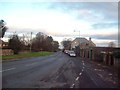
Stumperlowe Hall Road
Stumperlowe Hall Road meets Tom Lane and Carsick Hill Crescent.
Image: © DS Pugh
Taken: 24 Aug 2018
0.14 miles
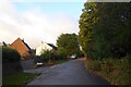
6
Tom Lane
Looking along Tom Lane near the junction with Carsick Hill Crescent.
Image: © DS Pugh
Taken: 24 Aug 2018
0.15 miles
7
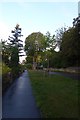
Along Tom Lane
Ascending Carsick Hill along Tom Lane.
Image: © DS Pugh
Taken: 24 Aug 2018
0.15 miles
8
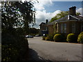
The entrance to Claremont Hospital
A private hospital at Sandygate, Sheffield.
Image: © Peter Barr
Taken: 30 Sep 2010
0.15 miles
9
Sandygate Road in Crosspool
Looking along Sandygate Road from its junction with Pitchford Lane.
Image: © Jonathan Clitheroe
Taken: 22 Nov 2011
0.18 miles
10
Belgrave Road Conservation Area
Run by Sheffield University
Image: © N Chadwick
Taken: 13 May 2006
0.19 miles