IMAGES TAKEN NEAR TO
Ashgate Road, SHEFFIELD, S10 3BZ
Introduction
This page details the photographs taken nearby to Ashgate Road, S10 3BZ by members of the Geograph project.
The Geograph project started in 2005 with the aim of publishing, organising and preserving representative images for every square kilometre of Great Britain, Ireland and the Isle of Man.

There are currently over 7.5m images from over14,400 individuals and you can help contribute to the project by visiting https://www.geograph.org.uk
Image Map
Images are licensed for reuse under creativecommons.org/licenses/by-sa/2.0
Notes
- Clicking on the map will re-center to the selected point.
- The higher the marker number, the further away the image location is from the centre of the postcode.
Image Listing (166 Images Found)
Images are licensed for reuse under creativecommons.org/licenses/by-sa/2.0
Image
Details
Distance
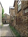
1
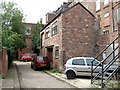
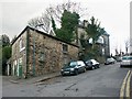
Ashgate Lane, Broomhill
This two-story building is very probably an outside store used to house recently delivered goods for the shops.
Image: © Dave Hitchborne
Taken: 6 Aug 2008
0.00 miles
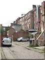
2
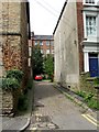
Ashgate Lane, Broomhill
Looking from Ashgate Road towards the backs of the shops on Fulwood Road. At the red car, the lane turns to the right and runs parallel to the main roads. Note the cobbled road. This was how the main road was not so long ago.
Image: © Dave Hitchborne
Taken: 6 Aug 2008
0.01 miles
3
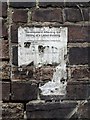
Ashgate Lane, Broomhill
Old Listed Building notice.
Image: © Dave Hitchborne
Taken: 6 Aug 2008
0.01 miles
4
Ashgate Lane, Broomhill
A look back along the lane.
Image: © Dave Hitchborne
Taken: 6 Aug 2008
0.01 miles
5
Ashgate Lane, Broomhill
Looking out onto Ashgate Road.
Image: © Dave Hitchborne
Taken: 6 Aug 2008
0.01 miles
6
Ashgate Lane, Broomhill
Showing the backs of the shops on Fulwood Road.
Image: © Dave Hitchborne
Taken: 6 Aug 2008
0.02 miles
7
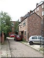
Ashgate Lane, Broomhill
This narrow lane barely separates the rear of the houses from the rear of the shops. Delivery drivers very probably hated having to come down here and offload their goods.
Image: © Dave Hitchborne
Taken: 6 Aug 2008
0.02 miles
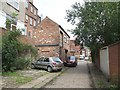
8
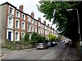
Ashgate Road, Broomhill
Looking north eastwards towards Glossop Road.
To the left is Ashgate Lane, which runs around the backs of these well-built three-storey houses and then back onto Ashgate Road.
Image: © Dave Hitchborne
Taken: 6 Aug 2008
0.02 miles
9
Fulwood Road, Broomhill
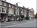
Walking further east and looking back at the church http://www.geograph.org.uk/photo/987789 ...and working back towards me, we have, Oxfam, Fruit-A-Peel (groan), Your Nuts (groan, groan), SM Hair, the Post Office (which is only shown as one shop front in the Planning Portal), and then an unidentified shop, which appears to have been a florists judging by the Interflora sign. I should have taken a shot of the post box twins - drat!
Note the A57 road marking, which is indicating the route to Manchester. Not that it is any big deal, but you nowadays find that main roads to anywhere circumnavigate a city, rather than go through it.
Image: © Dave Hitchborne
Taken: 6 Aug 2008
0.03 miles
10
Ashgate Road, Broomhill
The top of this road used to have access to Fulwood Road, but now it is blocked off. The A57 to Manchester is just over the brow of the hill.
Image: © Dave Hitchborne
Taken: 19 Feb 2004
0.03 miles