IMAGES TAKEN NEAR TO
Glossop Road, SHEFFIELD, S10 2PX
Introduction
This page details the photographs taken nearby to Glossop Road, S10 2PX by members of the Geograph project.
The Geograph project started in 2005 with the aim of publishing, organising and preserving representative images for every square kilometre of Great Britain, Ireland and the Isle of Man.

There are currently over 7.5m images from over14,400 individuals and you can help contribute to the project by visiting https://www.geograph.org.uk
Image Map
Images are licensed for reuse under creativecommons.org/licenses/by-sa/2.0
Notes
- Clicking on the map will re-center to the selected point.
- The higher the marker number, the further away the image location is from the centre of the postcode.
Image Listing (230 Images Found)
Images are licensed for reuse under creativecommons.org/licenses/by-sa/2.0
Image
Details
Distance
1
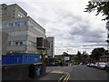
The Physios - or more correctly - the physios, Beech Hill Road, Sheffield - 1
Although a close neighbour of the Royal Hallamshire Hospital,
which is just across the road … the physios is an independent business
The lack of capitals in the title is confirmed in the signage on …
Image
Image: © Terry Robinson
Taken: 14 Aug 2012
0.01 miles
2
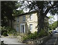
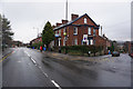
Early Victorian house with a hospital behind
Between Broomhill and Broomhall, Sheffield. The hospital in question is The Royal Hallamshire which was opened by the Prince of Wales in 1978. The Victorian house is now also connected with some aspect of healthcare.
Image: © Neil Theasby
Taken: 7 Sep 2019
0.01 miles
3
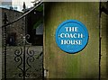
"The Coach House", St Mark's Crescent, Broomhall
The way the sinking sunlight caught "The Coach House" sign on the stone gatepost meant I was obliged to get my camera out. Behind in the top left of this picture you can see some of the facade of The Royal Hallamshire Hospital.
Image: © Neil Theasby
Taken: 7 Sep 2019
0.01 miles
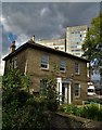
5
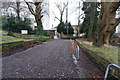
Beech Hill Road and the Hallamshire hospital Sheffield
Image: © Steve Fareham
Taken: 3 Aug 2015
0.02 miles
6
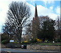
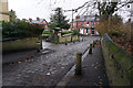
Broomhill, Sheffield 10
St Mark's Church on St Mark's Crescent is seen here on the opposite side of Glossop Road (the B6547) from a corner of College Street. Glossop Road carries traffic away from the city and the front of the Royal Hallamshire Hospital (both on the right) towards the A57 (the main Sheffield to Manchester Road).
Image: © David Hallam-Jones
Taken: 8 Apr 2014
0.02 miles
8
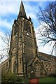
St Mark's Church - the Tower
The only part of the Church to survive the bombing in 1941. The original entrance can be seen. This is now part of the vestry.
Image: © Keith Pitchforth
Taken: 21 Nov 2008
0.03 miles
10
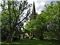
St Mark's Church, Broomhill, Sheffield
Seen across St Mark's Green.
Image: © Neil Theasby
Taken: 7 Sep 2019
0.03 miles